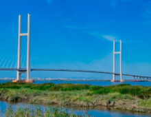
  Analysis North Korea and China upgraded nearly all border trade crossings in 2020In a likely push for trade, Pyongyang and Beijing poured resources into roads and other projects for a post-COVID-19 era 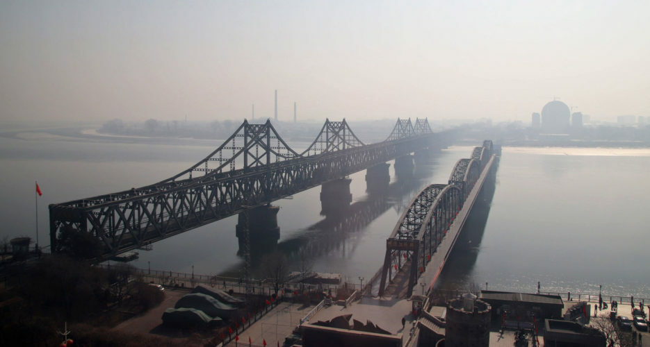 Editor’s note: This analysis is part of a three-part series on China-North Korea relations in 2020. See part one here and part two here. North Korea and China are working to create cross-border business opportunities on a never-before-seen scale, building up new economic parks and customs facilities on both sides of the border in 2020, despite the shadow of economic sanctions and COVID-19. NK Pro analysis of Chinese media and satellite imagery reveals the scope of construction and preparations across the entire length of the China-DPRK border. In total, the countries started expanding 12 of the 13 road or rail bridge crossings in the last year alone. After decades of ambitious talk about establishing new special economic zones, the widespread activity on the ground may be a sign that stakeholders on both sides of the border expect sanctions to soon fade and cross-border interactions to rise.  The following sections each represent a different DPRK-China border crossing, and are organized in the order of their location along the border, from west to east: SINUIJU-DANDONG A combination rail and road bridge called the DPRK-China Friendship Bridge — which connects the hearts of North Korea’s Sinuiju and China’s Dandong — currently serves as the main artery for land traffic-based trade between the two countries. In 2020, the bridge was observed operating on several occasions, but Pyongyang authorities have also reportedly closed or slowed activity at this port at times as part of COVID-19-related restrictions. 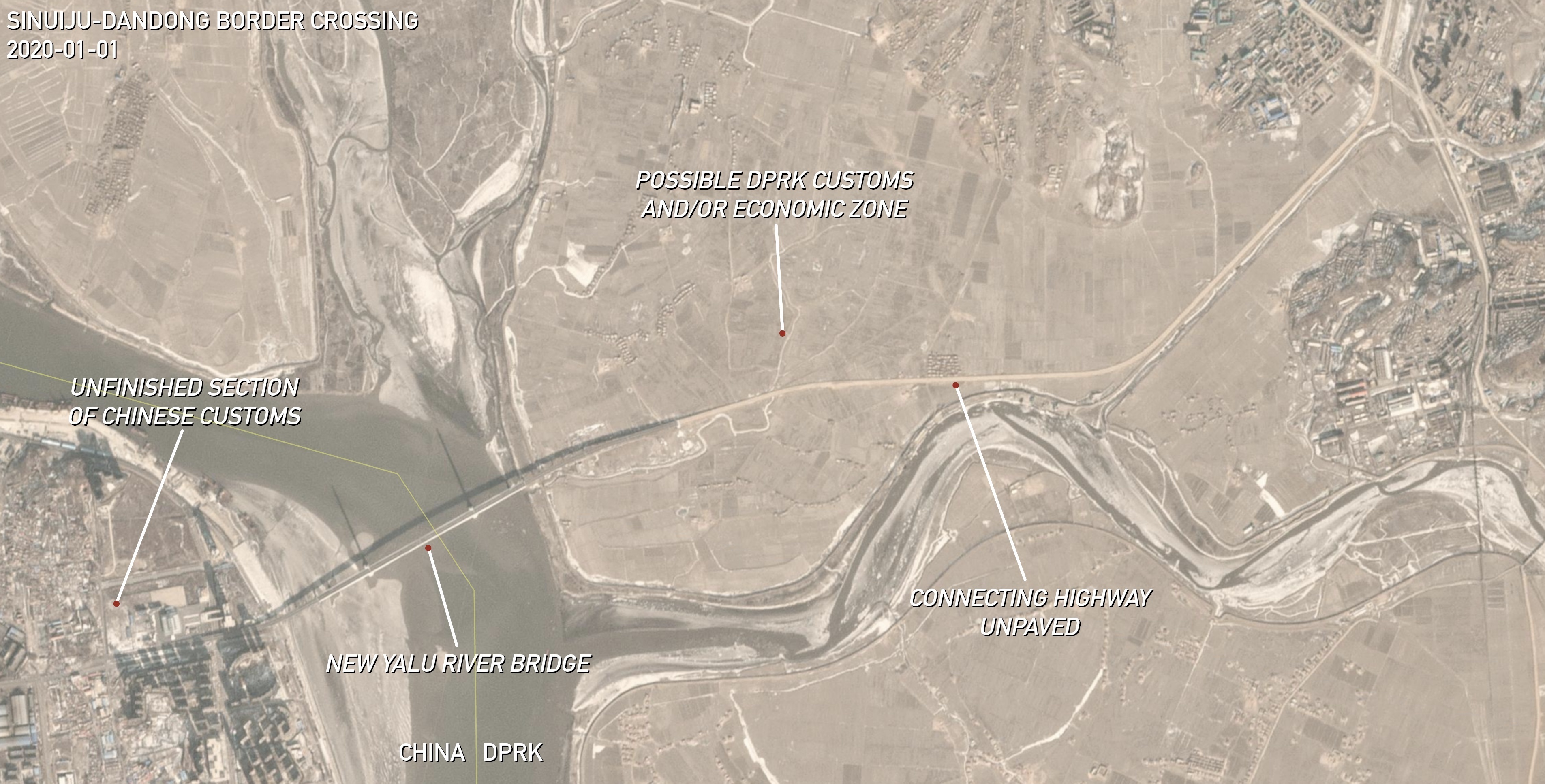 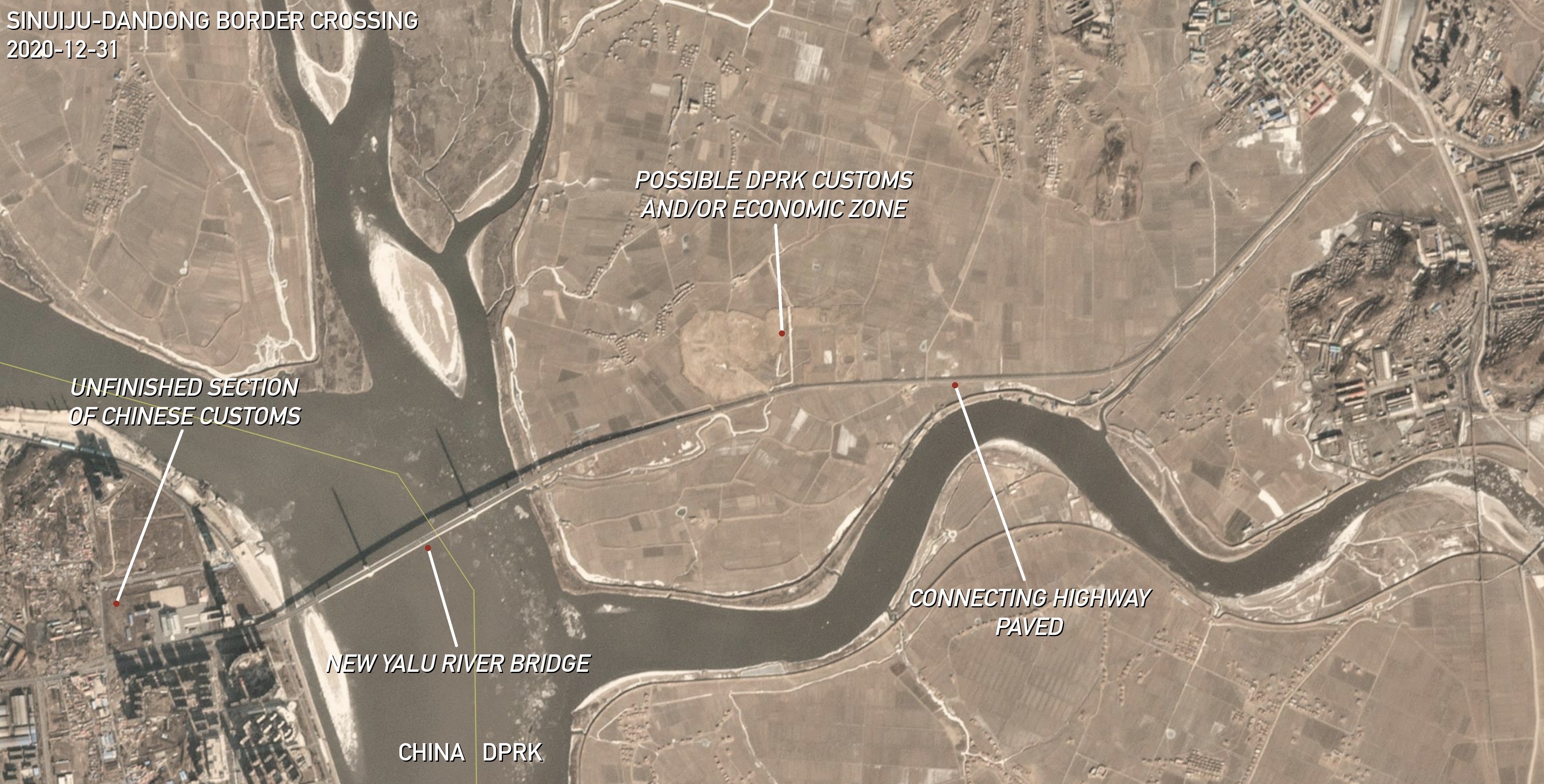 Coordinates: 40°02’14.84″ N 124°22’17.04″ E. | Images: © 2020 Planet Labs Inc. All Rights Reserved. Reprinted by permission. Edited by NK Pro.More significant developments have appeared just outside town on the North Korean side, where work began in late 2019 to finally connect the New Yalu River Bridge — a multi-million dollar project mostly completed by China in 2013 — to DPRK highways. This new work began just months after Chinese President Xi Jinping reportedly promised to help kickstart the connecting road project during his summit with DPRK leader Kim Jong Un in Pyongyang. Work to fully pave the new road appeared to wrap up in Oct. 2020, bringing the new border crossing very close to opening. However, the opening may have to wait until new customs facilities are built on the North Korean side. This project appears to be underway, as a large area of land at the foot of the bridge has been cleared out in recent months, but construction on any buildings has yet to begin, according to the latest satellite imagery. This area may also house a new economic park, and perhaps will be the location of a long-planned, wholly-Chinese-owned economic park on DPRK land.  China mostly finished their own large customs and processing complex back in 2015 in anticipation of a speedier opening of the bridge. However, some of the finished buildings currently remain surrounded by dirt. If workers start to pave the entire complex, that could be another sign that the bridge is about to open imminently. SAKJU-KUANDIAN A much smaller and less significant border crossing is located up the river from the main trade and tourist corridor of Sinuiju-Dandong. This crossing has also seen expansion efforts in recent years, and even in 2020. It consists of inland river ports and a rail bridge connecting North Korea’s Sakju County and China’s Kuandian Manchu Autonomous County (宽甸县). The most recent activity has been on the Chinese side. Planet Labs and Google Earth satellite imagery reveal that the parking or loading lot at the Taiping Bay Port (太平湾口岸) was expanded and paved in April 2020. Efforts to boost local tourism were also made in 2017 with the construction of a new river boat tour port and a new “Railway Museum of Resisting U.S. Aggression and Aiding North Korea (铁路抗美援朝博物馆).” 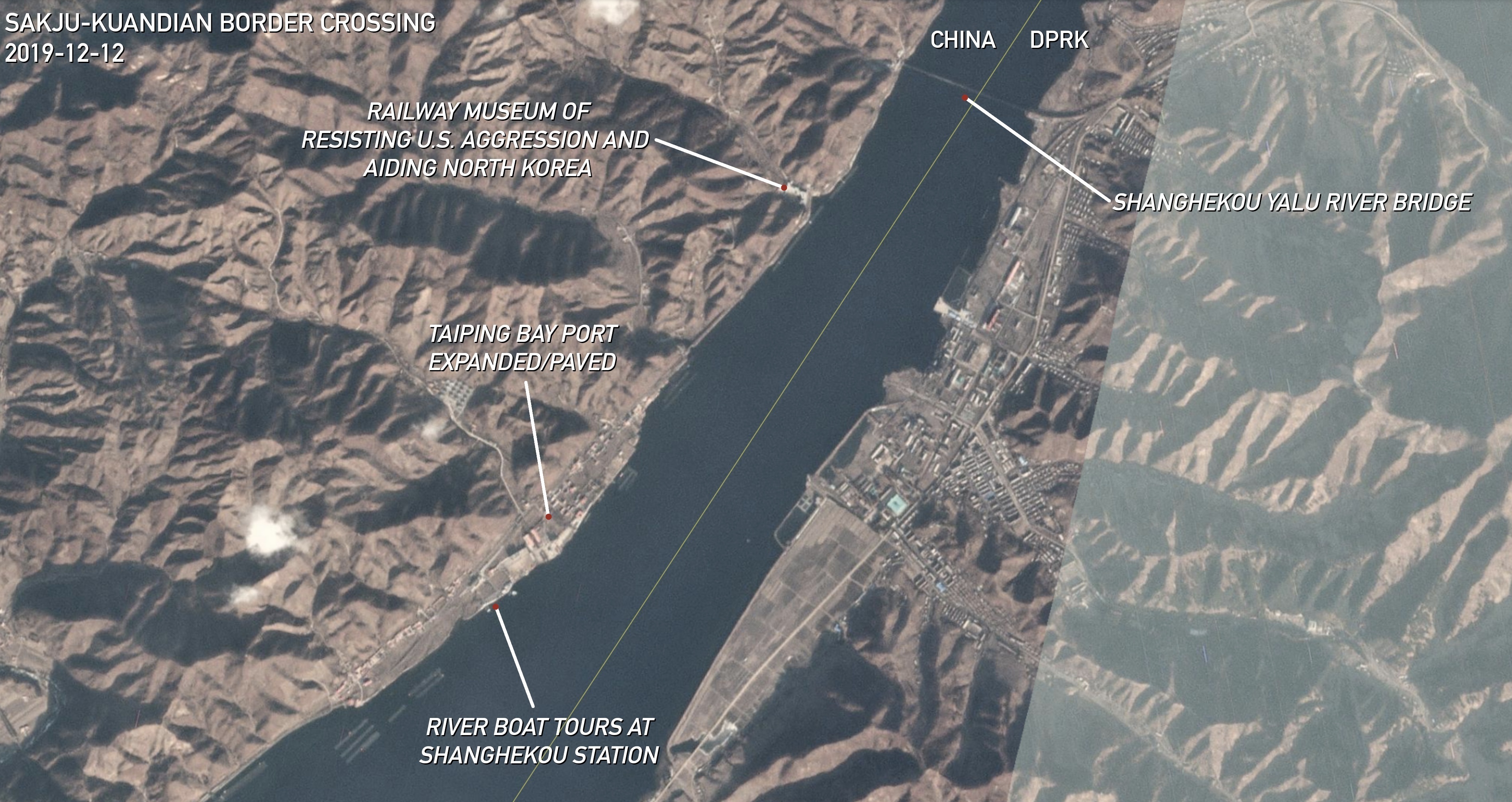 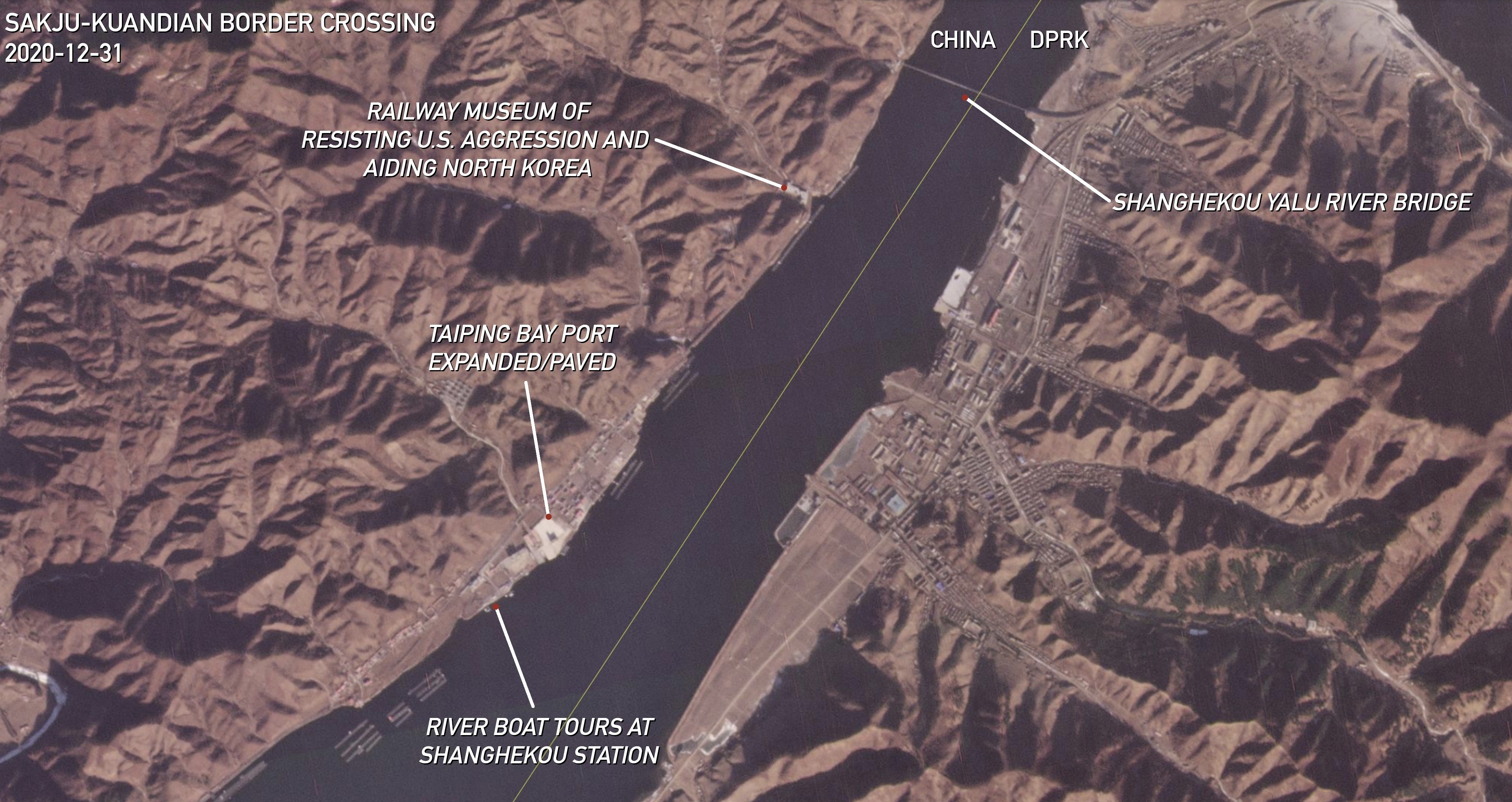 Coordinates: 40°26’58.01″ N 124°51’57.33″ E. | Images: © 2020 Planet Labs Inc. All Rights Reserved. Reprinted by permission. Edited by NK Pro. This museum was built next to a fully-intact, cross-border rail bridge called the Shanghekou Yalu River Bridge (上河口鸭绿江大桥). China actually upgraded their side between 2014 and 2016, Google Earth imagery shows, installing a large gate over the tracks at the base of the bridge. But according to an Aug. 2020 report by local news outlet Qibuzi, the tracks are rusted and have not been used to transport trains to North Korea for years. Meanwhile, North Korea has been promoting the idea of establishing the Chongsu Tourism Development Park (청수관광개발구 / 清水观光开发区) on their side of the river since 2014, but the plans have yet to materialize on the ground. MANPHO-JIAN One of the largest new customs complexes built on the Chinese side of the border in recent years is in Jian, across the border from North Korea’s Manpho in Jagang Province. The complex and a grid of surrounding roads to service the new Jian Border Economic Cooperation Zone (集安边境经济合作区) were completed in 2018, but the customs facilities and cross-border road bridge have not been very busy, according to a review of satellite imagery and photos posted on Chinese social media sites. But Planet Labs satellite imagery reveals that new buildings have sprung up in the economic park in the last six months of 2020, and preparations appear underway in other empty lots to build even more. Local party authorities in Tonghua released a report in July 2020 declaring intentions to use the zone to boost imports of raw materials from the DPRK. It also said that local Chinese companies are already investing millions of dollars — despite U.N. sanctions prohibiting this activity — to develop a number of industrial plants on North Korean land. 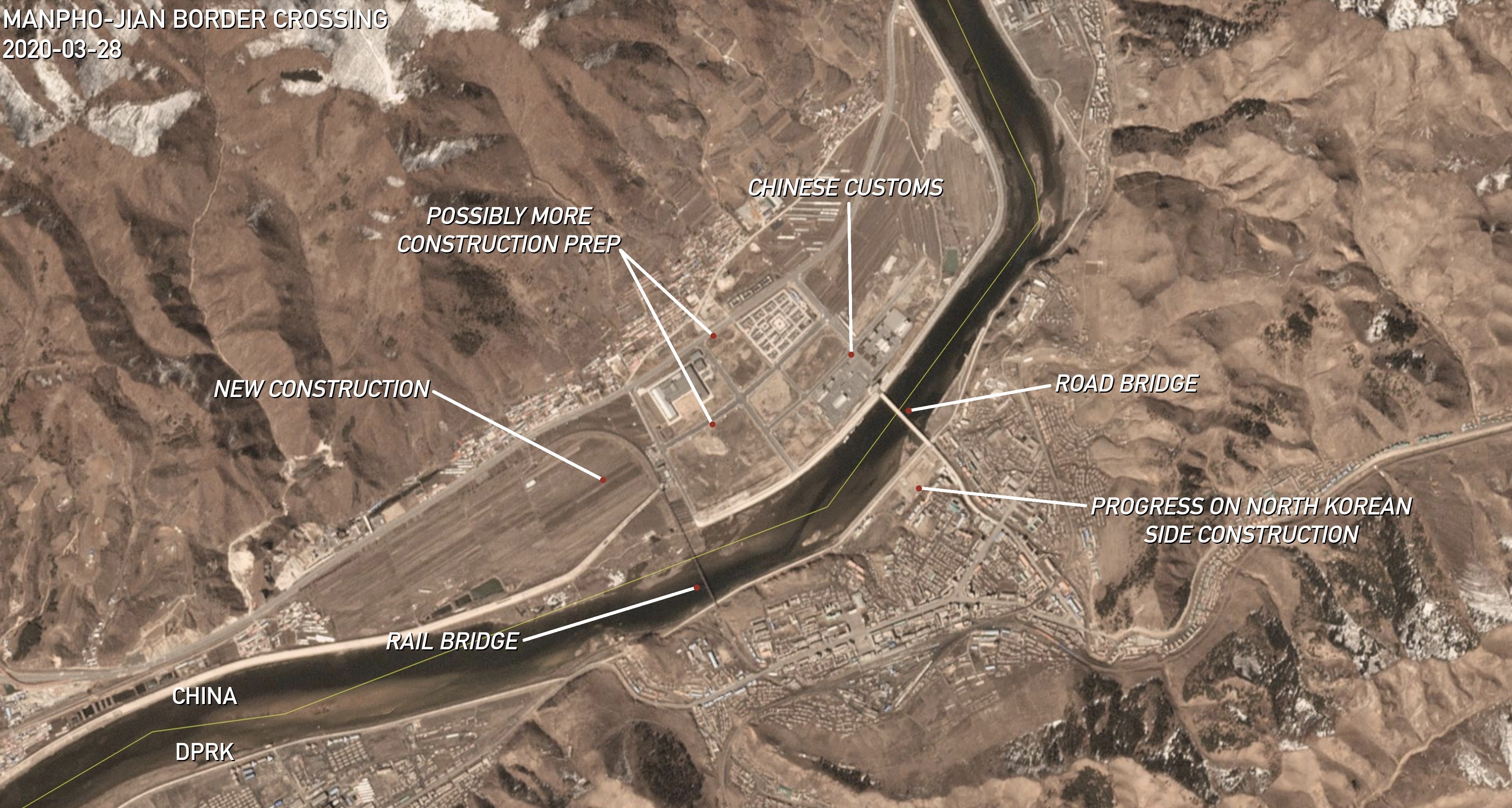 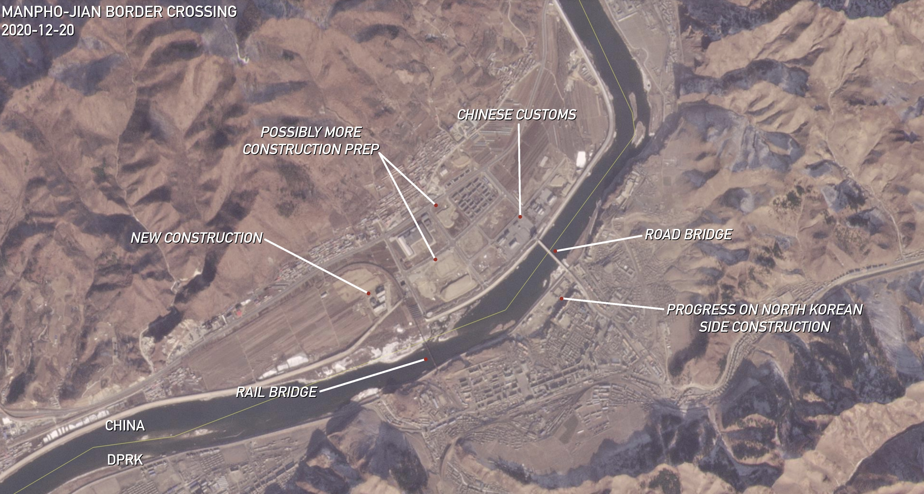 Coordinates: 41°09’48.73″ N 126°16’58.31″ E. | Images: © 2020 Planet Labs Inc. All Rights Reserved. Reprinted by permission. Edited by NK Pro.Satellite imagery also shows that North Korea restarted construction on a new building next to the road bridge entrance in Aug. 2020, though the building’s purpose is not clear. In addition to the road bridge, an active railway bridge also connects the two towns. It has carried trains of Chinese tourists down to Pyongyang for years, which also recently began stopping in more places in North Korea along the way. The number of tourists passing through Manpho was also growing rapidly in 2019, before the COVID-19 border shutdown, according to the aforementioned July 2020 Tonghua CPPCC report. The report stated that 7,200 tourists crossed into Manpho in 2019, representing roughly 40% of the total number through the crossing since 2014. In addition to tourists, the report said that workers — which likely includes North Korean laborers traveling or commuting to businesses in China — crossed the border 115,000 times, or 633% higher in 2019 than in 2018. Most recently, in Nov. 2020, the Tonghua News Network reported that local Jian officials renewed calls to expand bilateral trade with North Korea and build duty-free shops near the border. JUNGGANG-LINJIANG There’s a second border crossing connected to North Korea’s Jagang Province further north, where local officials and businesses in the Chinese city of Linjiang (临江市) are hoping to take advantage of North Korean labor across the border in the small county of Junggang (중강군). In April 2020, soon after the COVID-19 pandemic forced the border to shut, Chinese stakeholders gathered next to the road bridge to hold a groundbreaking ceremony for the Linjiang City China-DPRK Trade Processing Industrial Park (临江市中朝贸易加工产业园区), according to the China Jilin Network. A photo published with the report showed bulldozers clearing land next to the bridge, and Planet Labs satellite imagery reveals that two large buildings were built in the spot between June 2020 and Oct. 2020. However, a picture of blueprints bearing the same industrial park name, published by Linjiang Financial Media, shows that the zone will also occupy a piece of land further inland to the east.  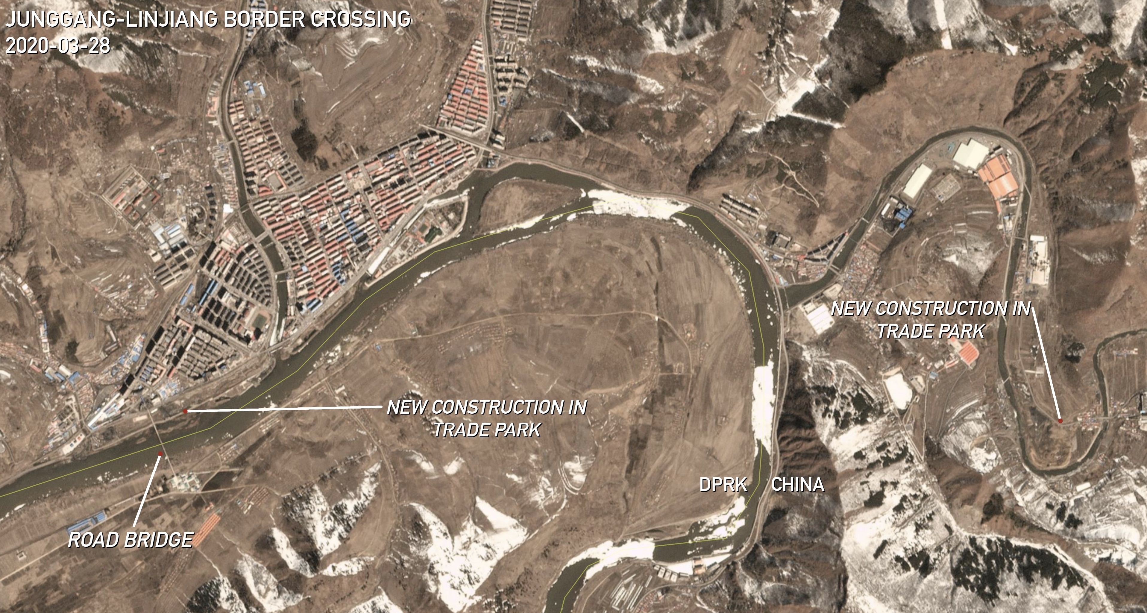 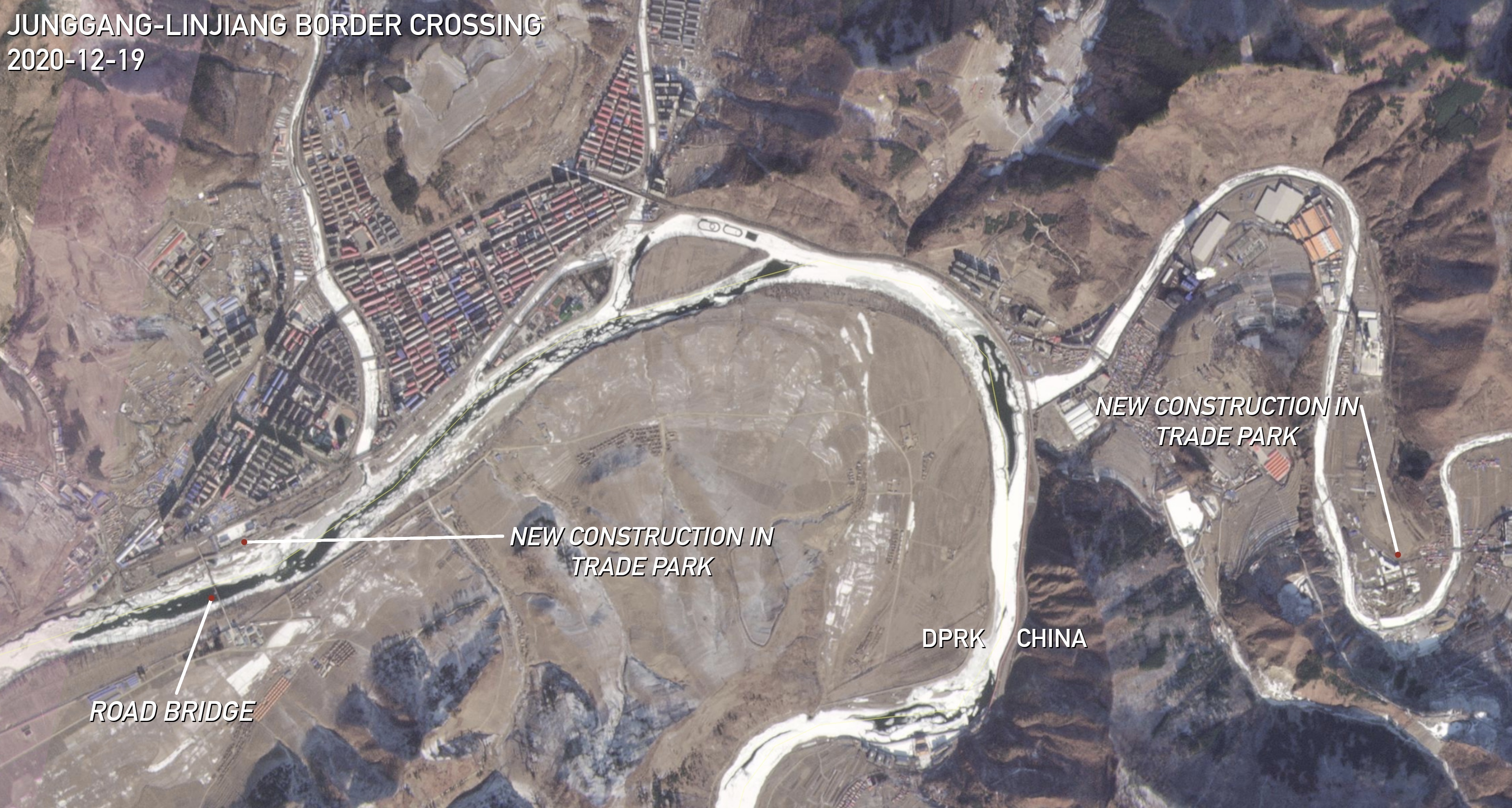 Coordinates: 41°47’36.05″ N 126°53’50.06″ E. | Images: © 2020 Planet Labs Inc. All Rights Reserved. Reprinted by permission. Edited by NK Pro.The China Jilin Network report also stated that the industrial park will offer jobs for up to 10,000 workers, likely including North Koreans, and that two large companies — the French clothing brand Decathlon and Jiangsu Hailan Home — have already agreed to set up operations there. A May 2020 report by the Jillin Daily also stated that more clothing companies were strongly considering moving into the zone. HYESAN-BAISHAN The Chinese city of Baishan, across from North Korea’s Hyesan, has been laying the groundwork for a large economic park near a cross-border road bridge since before Kim Jong Un came to power. Little development took place there in the years since, but new warehouses were built there in Oct. 2020 — again, in the midst of sanctions and the COVID-19 border lockdown. 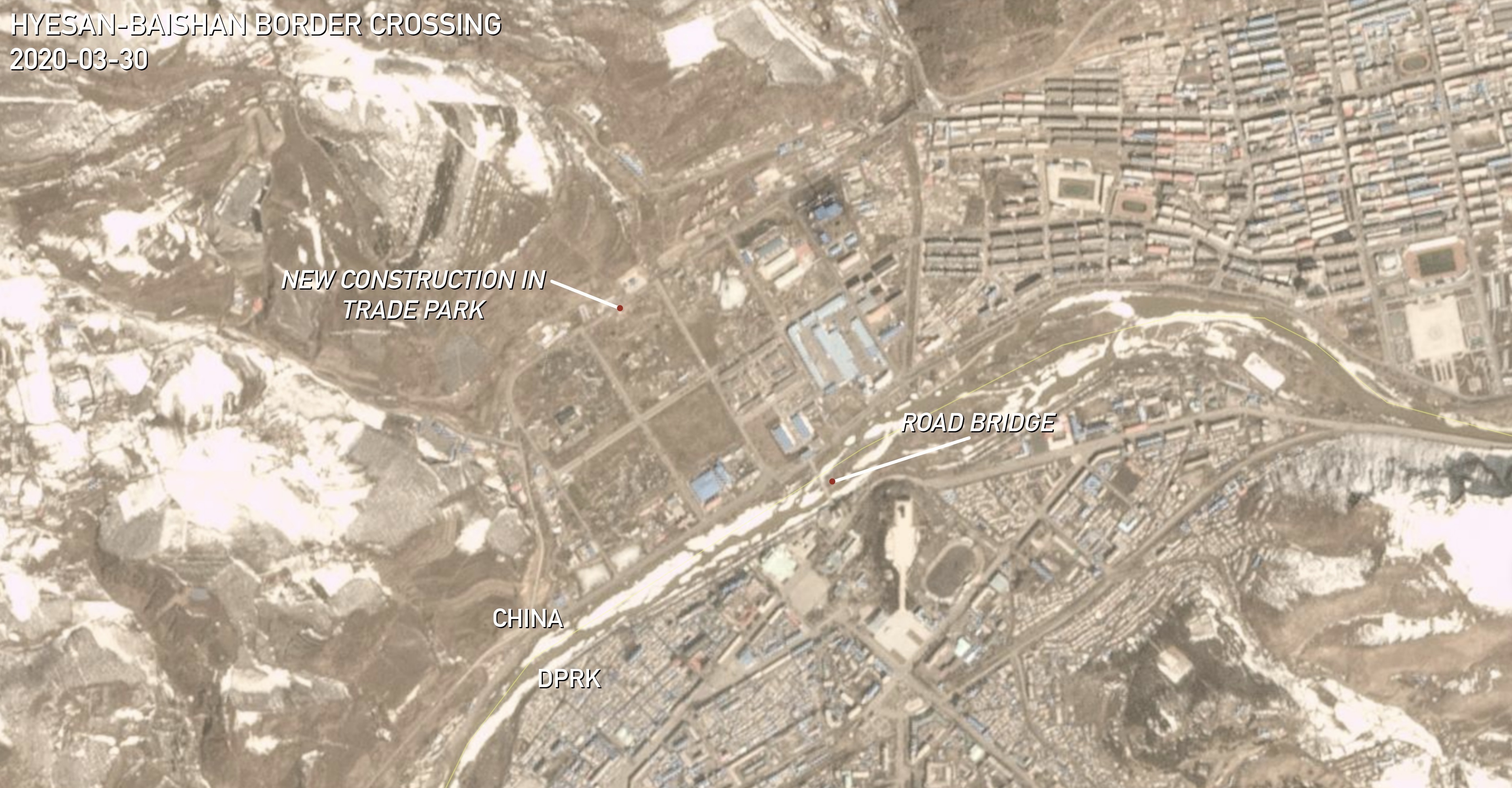 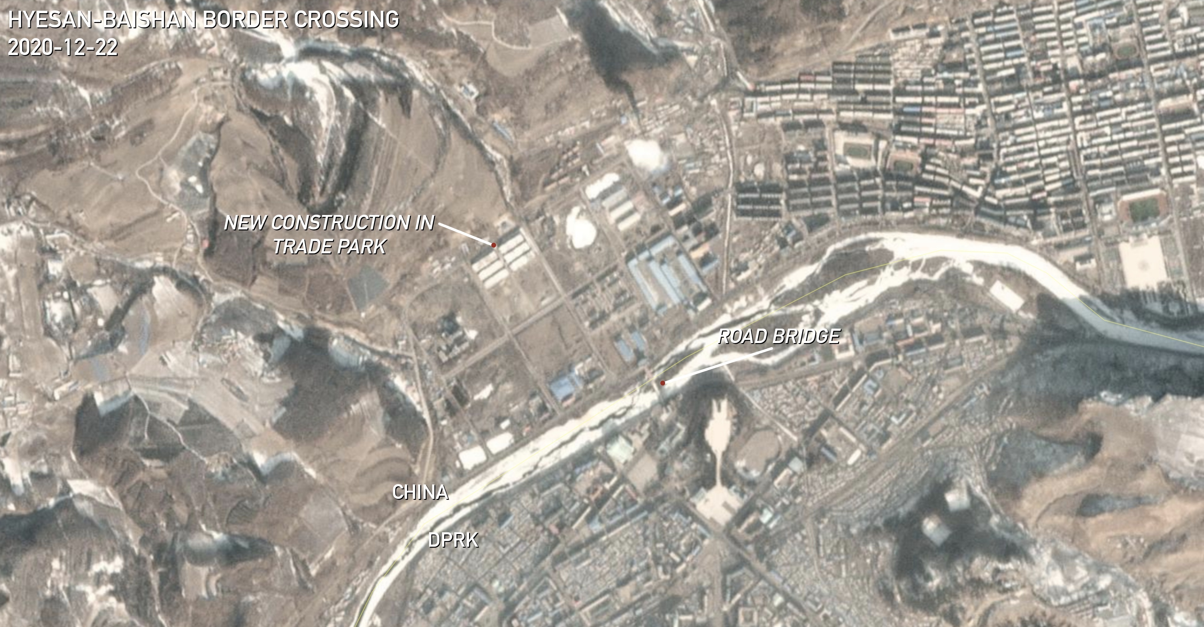 Coordinates: 41°24’29.28″ N 128°10’26.61″ E. | Images: © 2020 Planet Labs Inc. All Rights Reserved. Reprinted by permission. Edited by NK Pro.However, there are still a number of empty lots in the economic park, while the China Changbai Port International Trade City (中国长白口岸国际商贸城 / 중국장백통상구국제상업무역성) directly adjacent to Chinese customs has reportedly languished for years. But the new developments signal that some on the Chinese side in Baishan and Changbai Korean Autonomous County are preparing for more imminent cross-border economic opportunities. Meanwhile, on the North Korean side, there does not appear to have been any new border-related construction since the customs building at the foot of the bridge was rebuilt in 2016. SAMJIYON-CHANGBAI The cross-border road checkpoint next to Mount Paektu — the large mountain with a crater lake that straddles the border — is the most remote border crossing between the two countries. But it also appears to be important to both countries, which made rapid developments to improve the link in the last year. For China, this mostly involves building the new Changbaishan Customs Office (长白山海关) in the nearest town to the north in Antu County. At its opening ceremony in Aug. 2020, local officials claimed it would allow local businesses to avoid the hassle of going through customs procedures in faraway offices, and instead process goods to be carried down the road directly into North Korea’s Samjiyon.  The nearest North Korean village near the border crossing, Sinmusong, saw significant new construction in 2020 as well, though this is generally part of the larger project to rebuild the entire politically symbolic Samjiyon region. However, the developments are intended to bring in more tourists from China and abroad, meaning that the remote border crossing could see more traffic in the future. SAMJANG-CHONGSHAN An often-overlooked road bridge links a small DPRK village named Samjang in Taehongdan County and the small Chinese town of Chongshan (崇善镇), near where North Korea’s Ryanggang and North Hamgyong provinces meet. And though this crossing is also relatively remote, local Chinese officials appear eager to take advantage of the access. 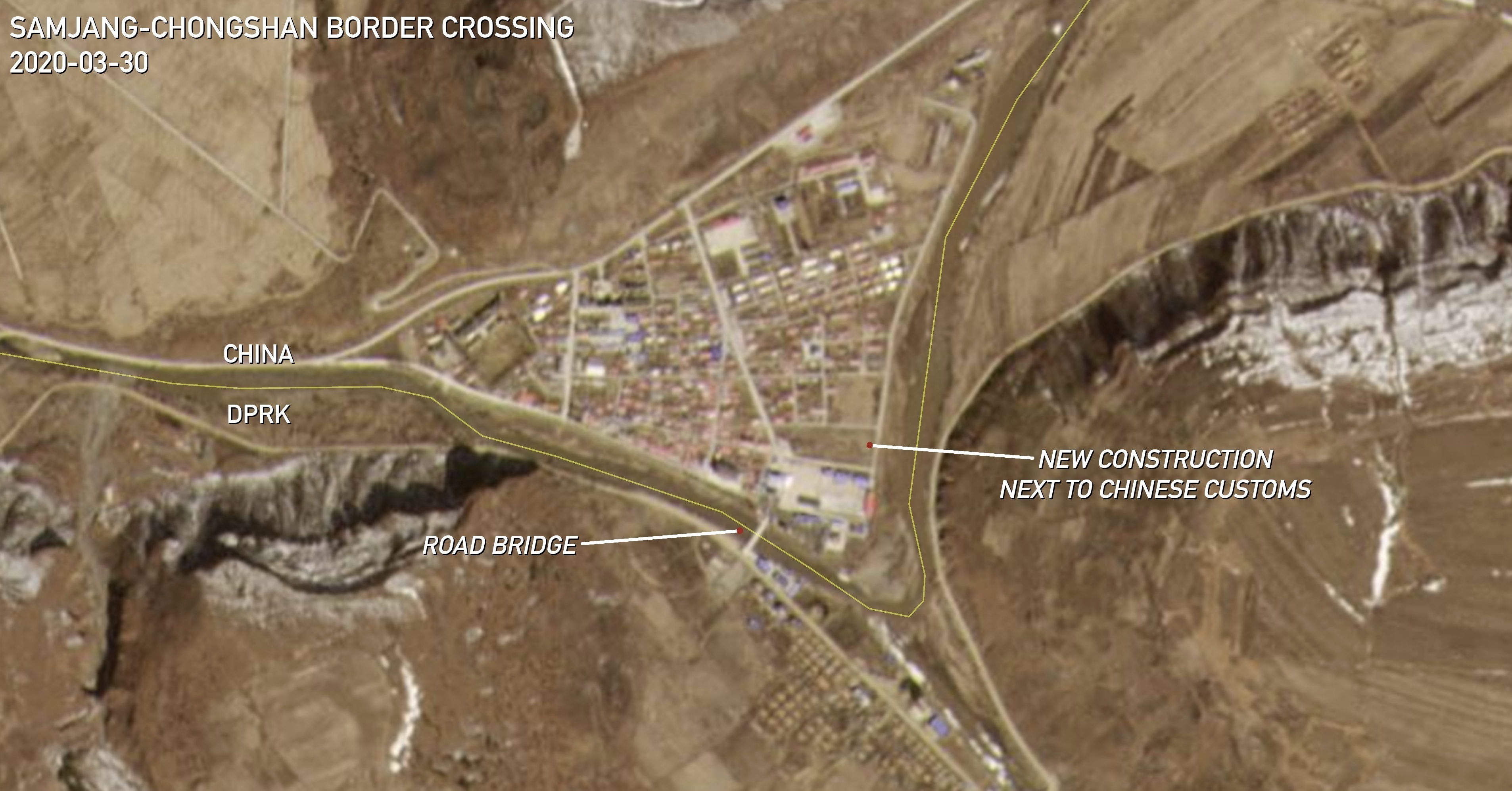 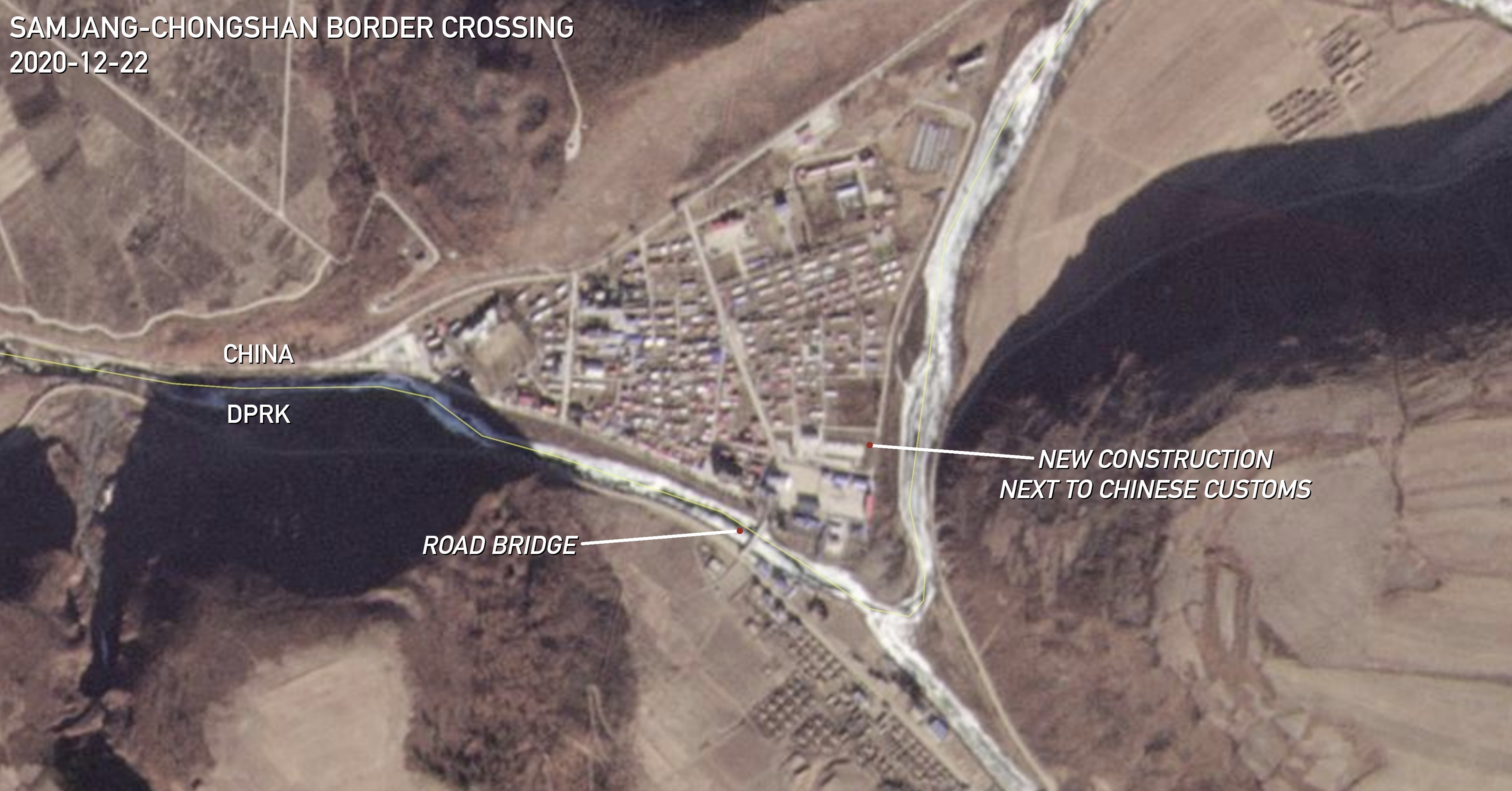 Coordinates: 42°05’24.98″ N 129°00’12.11″ E. | Images: © 2020 Planet Labs Inc. All Rights Reserved. Reprinted by permission. Edited by NK Pro.According to Planet Labs satellite imagery, construction on new developments directly adjacent to China’s Guchengli Port (古城里口岸) began in May 2020. It may be part of an announced renovation project to customs facilities. The Chinese have imported timber from North Korea at the port in the past, and even intercepted illegal deer antler imports there last year. MUSAN-NANPING Heading east along the border, the crossings from here begin to increase in frequency and potential for economic opportunities, with multiple Chinese cities and municipalities looking to take advantage of markets and labor in North Korea’s North Hamgyong Province and the Rason Economic and Trade Zone (라선경제무역지대). 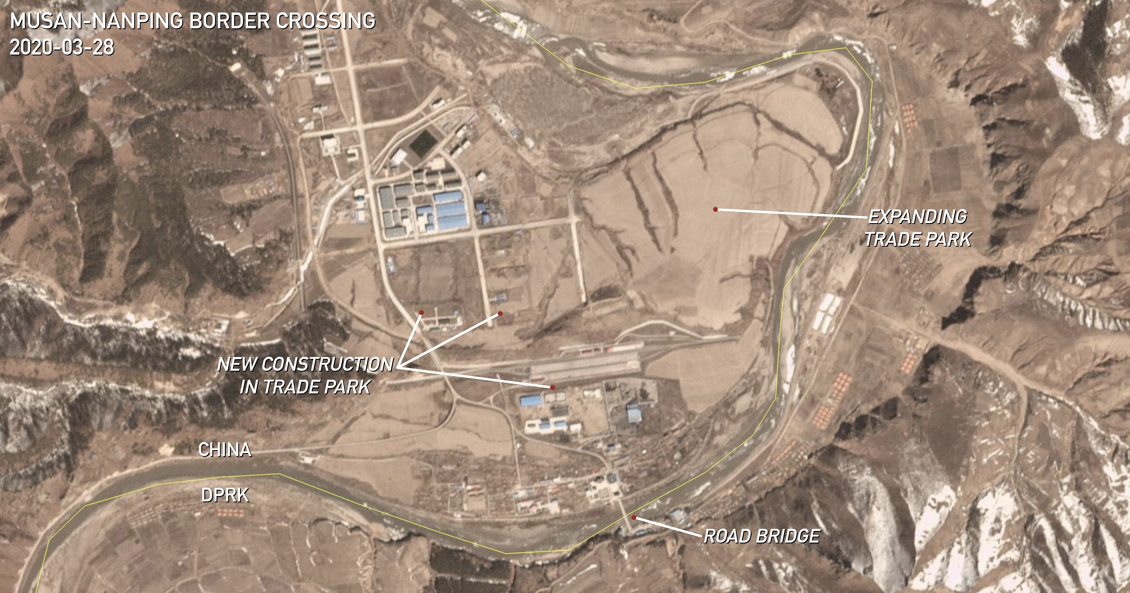 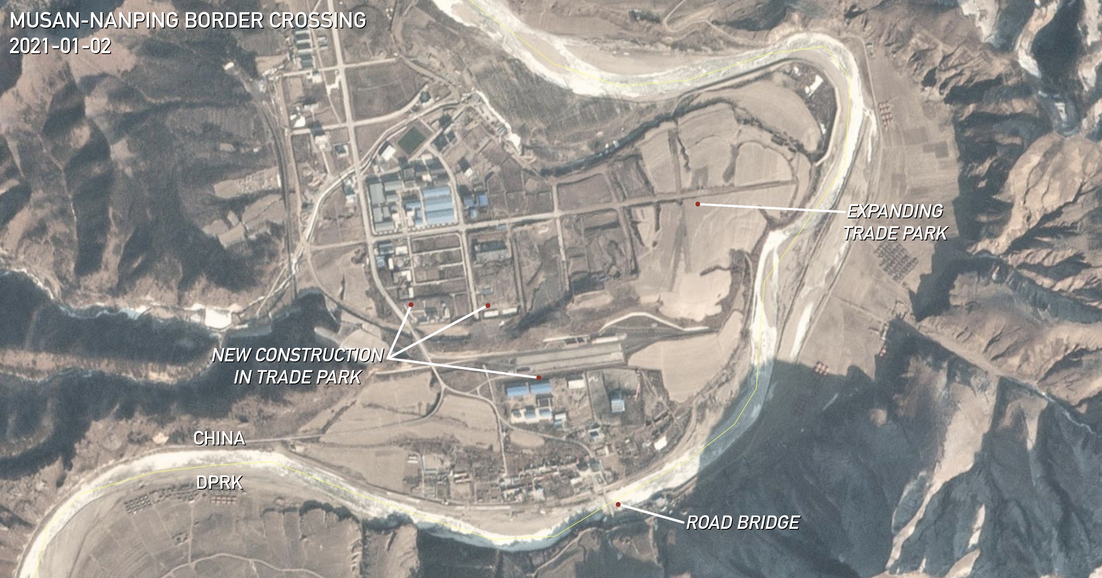 Coordinates: 42°16’38.88″ N 129°11’47.93″ E. | Images: © 2020 Planet Labs Inc. All Rights Reserved. Reprinted by permission. Edited by NK Pro.Like many others, the road bridge connecting North Korea’s Musan and China’s Nanping allows DPRK workers to find employment in Chinese factories across the border, where construction ramped up in 2020. Development has been ongoing since May 2020 in multiple formerly empty lots in the Helong Border Economic Cooperation Zone (和龙边境经济合作区), according to Planet Labs satellite imagery. A top local government official visited the site in Aug. 2019 to promote local investment opportunities in the zone and the apparent high volume of trade going over the border bridge. Significantly, China also hopes to develop and exclusively operate economic parks on the North Korean side of the border, as well. A proposal was published by the Yanbian Korean Autonomous Prefecture in April 2019 detailing plans to establish textile processing and even automobile assembly plants in the North Korea Musan Extraterritorial Industrial Park (朝鲜茂山域外工业园区). HOERYONG-LONGJING The border area between Longjing in China and Hoeryong in North Korea is one of the least active, with no new economic park activity in the last year, but work does still appear to be active and ongoing in a complex near the cross-border road bridge on the Chinese side. 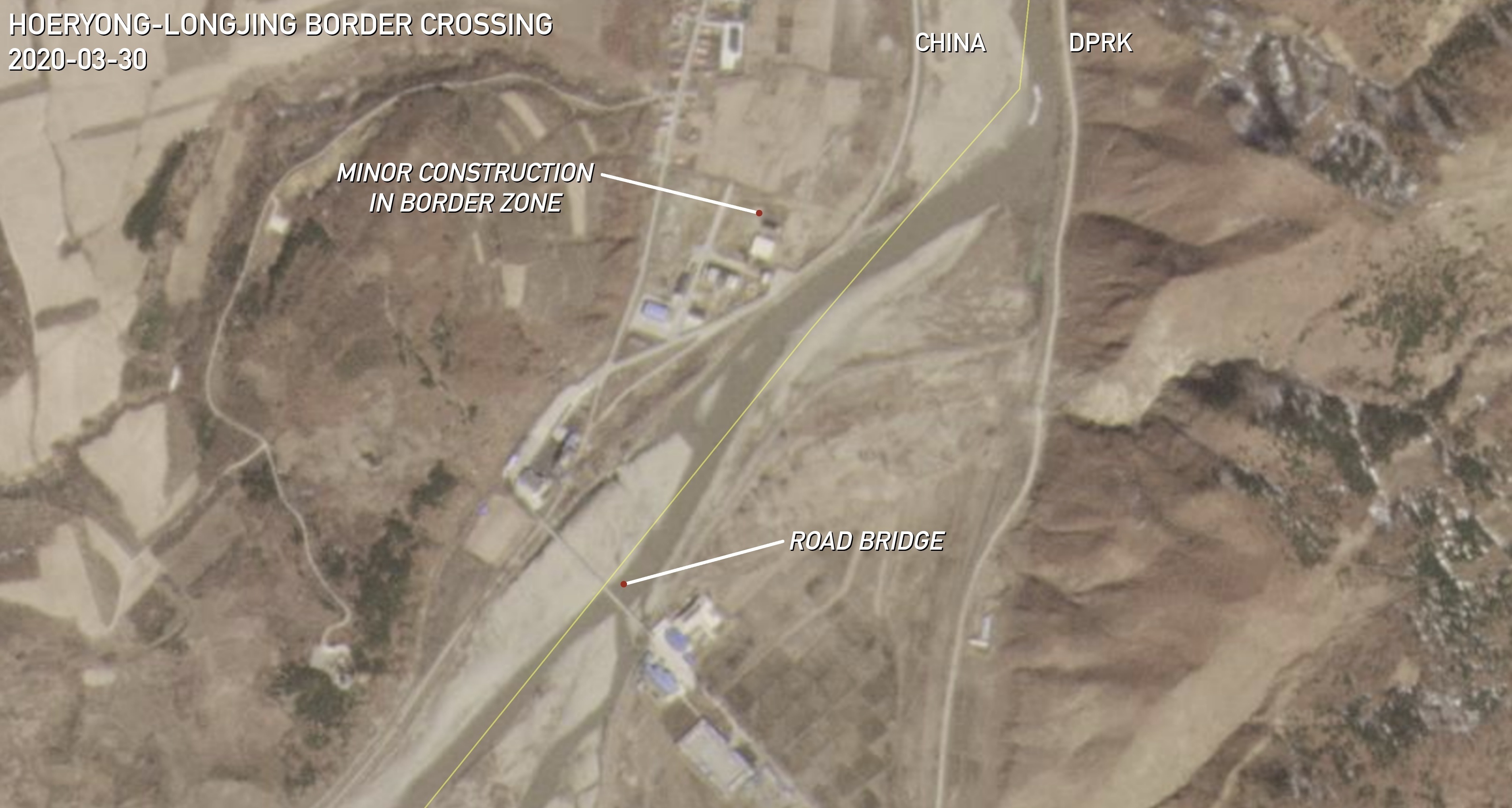 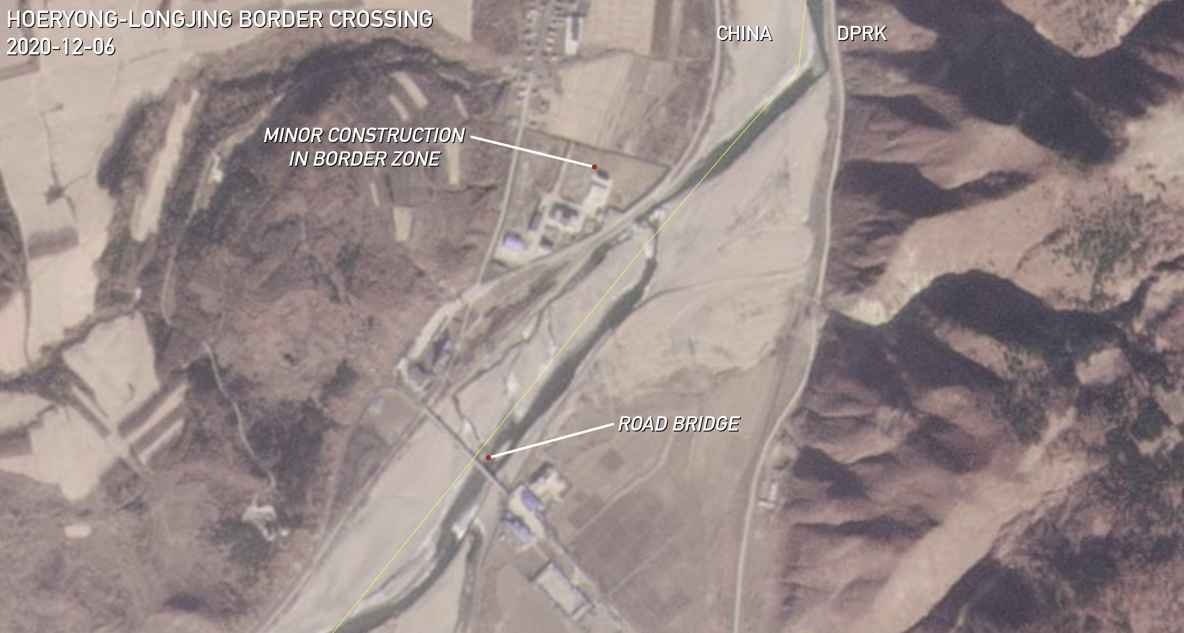 Coordinates: 42°28’07.78″ N 129°43’30.68″ E. | Images: © 2020 Planet Labs Inc. All Rights Reserved. Reprinted by permission. Edited by NK Pro.Satellite imagery reveals that minor paving work resumed in July 2020 around one of the buildings in the complex, where construction began in 2017 after major flooding damaged the area. SAMBONG-KAISHANTUN PORT Uniquely among the 13 border crossings, there appears to be no new construction on customs or economic parks at a checkpoint about 25 kilometers (15 miles) up the river from Hoeryong, between China’s Kaishantun Port (开山屯口岸) and a small village named Sambong in North Korea’s Onsong County.  The crossing consists of dedicated customs facilities on both sides of the border that were upgraded in the last seven years: China upgraded theirs between 2013 and 2015, and North Korea expanded their facilities from 2015 to 2018. NAMYANG-TUMEN Of all the crossings spanning the shared border, the newest to be modernized is the one between the Chinese city of Tumen and North Korea’s small town of Namyang. A brand new, four-lane road bridge was built across the river from 2016 to 2019, next to the old single-lane bridge. The new bridge will help drive local tourism, while Chinese companies are hoping to use it to move goods to DPRK east coast ports in Rason and Chongjin.  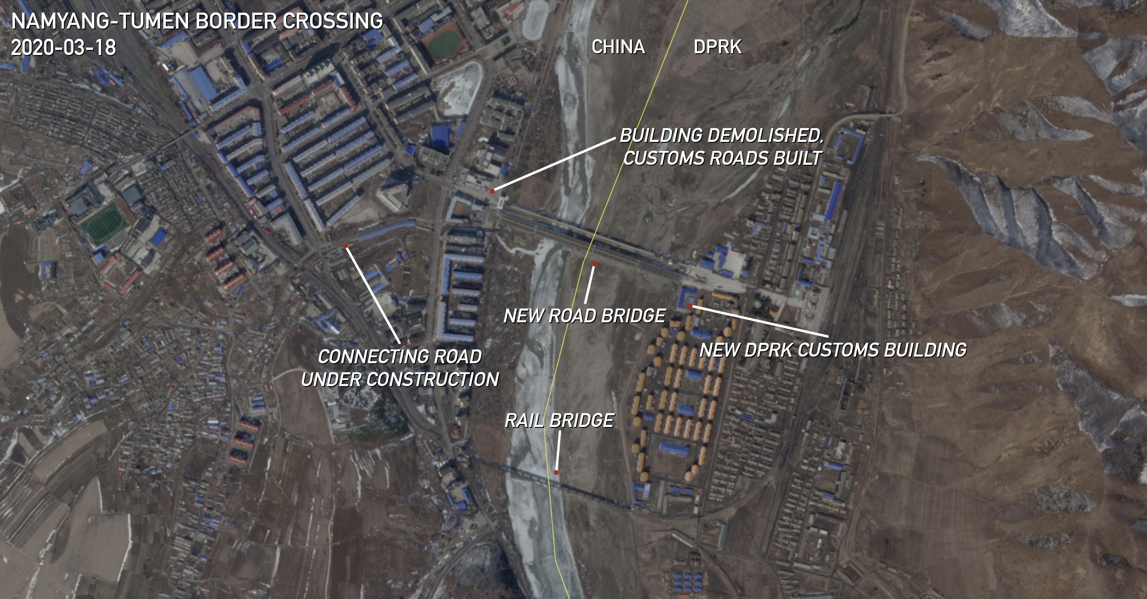 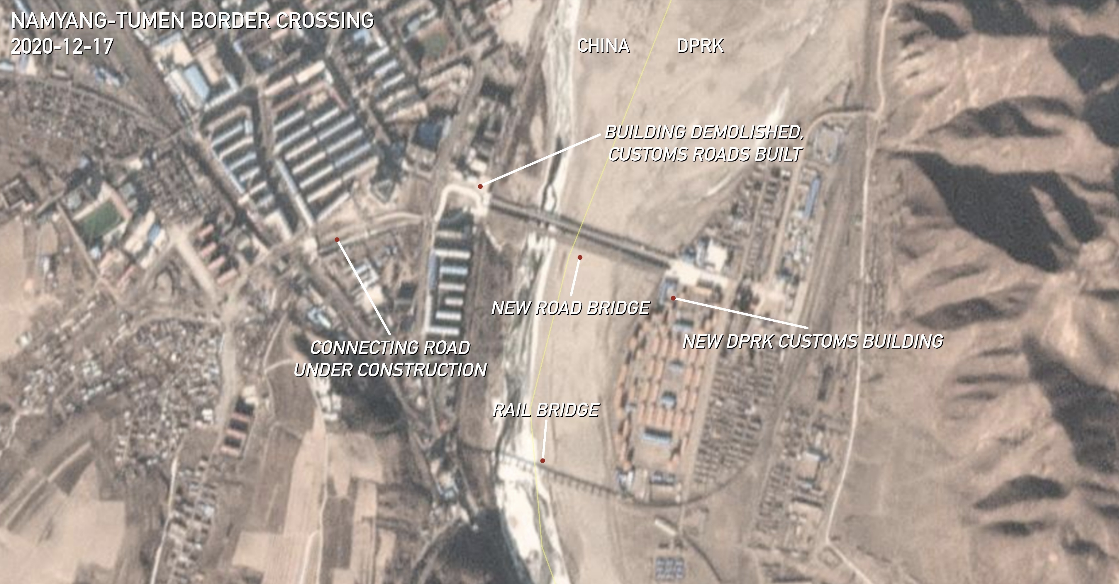 Coordinates: 42°57’33.12″ N 129°50’46.47″ E. | Images: © 2020 Planet Labs Inc. All Rights Reserved. Reprinted by permission. Edited by NK Pro.All that’s left now before the bridge actually opens — other than lifting the COVID-19 border closure — is for a new connecting road on the Chinese side to finish construction. A building standing in the way of the bridge was demolished in late June 2020, and work continued on the connecting road in the final months of the year. On the North Korean side, new customs facilities were built at the foot of the bridge in late 2019. Both sides have also nurtured a tourist circuit for Chinese daytrippers in recent years to Namyang, the nearby town of Onsong and even railway trips to North Korea’s Mount Chilbo. The Tumen government announced in Oct. 2020 that 10,000 Chinese tourists crossed the old bridge into Namyang back in 2019. RYUDA ISLAND-HUNCHUN The North Korean island of Ryuda (류다섬 / 柳多岛) — across from the Chinese city of Hunchun — is a full-fledged, planned special economic zone in partnership with China, and is unique among the border zones because it shows actual, new industrial-related construction on DPRK territory in the last year.  Plans for the zone are equally ambitious to the many blueprints and renders for other projects released over the last decade which do not materialize on the ground. But at least one company has already built a complex of buildings in what North Korea calls the Kyongwon Economic Development Zone (경원경제개발구) on Ryuda. If Chinese parties are involved, it would violate U.N. sanctions prohibiting joint ventures. At least one new bridge is planned across the narrow stream separating the land from China, according to the Ryuda zone’s blueprints released online, but it’s unclear if North Korea plans to upgrade their longer bridge crossing over the Tumen River to the mainland. RASON-HUNCHUN Another new bridge bookends the shared DPRK-border on the eastern side. Chinese businesses have utilized the Hunchun Quanhe Port (珲春圈河口岸) to access the Rason Economic and Trade Zone since the new four-lane road bridge finished construction in 2017. Around the same time, North Korea also built up trade facilities called the Wonjong Border Market (원정국경시장) and its customs facilities next to the foot of the bridge.  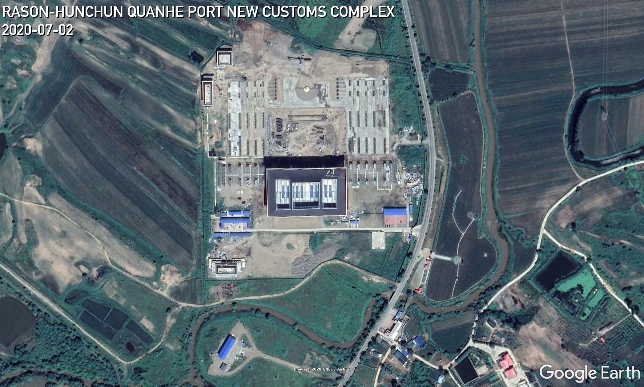 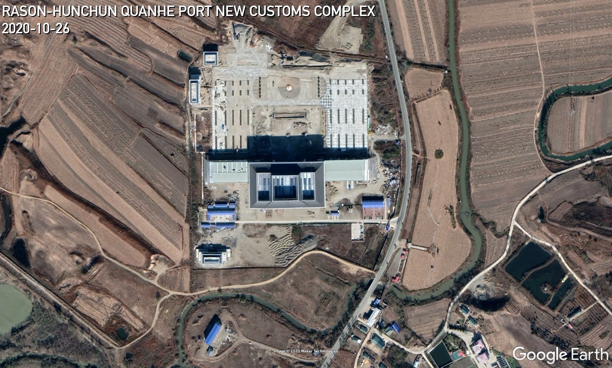 Coordinates: 42°34’24.05″ N 130°31’41.46″ E. | Images: Google Earth. Edited by NK Pro.China has also been working since 2017 on building a massive new customs complex just up the road from the bridge. It appears to have received a fresh boost from the local government in recent months, having restarted construction in Sept. 2020 after mostly stalling by the end of 2019, according to Planet Labs satellite imagery. CONCLUSIONS With evidence of 2020 expansion activity in all but one of the places along the DPRK-China border, it’s clear that both sides are eager to leave sanctions behind and grow cross-border trade and tourism to new levels. But for now, the border is likely to remain closed until the threat of the COVID-19 pandemic goes away. This makes it difficult to determine if all the construction is part of a true push to start ignoring U.N. sanctions on a grand scale, or if it is only the result of posturing by local officials, doomed to sit idle as Beijing continues to enforce sanctions in its frontier provinces. Edited by Kelly Kasulis © Korea Risk Group. All rights reserved. |

October 06, 2026Oct 06, 2026

The ultimate resources for professionals working on North Korea
 SHARE
SHARE COPY LINK
 X
X MASTODON