A flood-damaged home in Kumchon | Image: KCTV (Sept. 15, 2020)
Heavy rains and mudslides damaged newly built homes, roads and cropfields in northwest North Korea last week, including at the sprawling Yongbyon nuclear complex, according to NK Pro analysis of satellite imagery.
Planet Labs imagery shows widespread evidence of mudslides and swollen rivers and streams, primarily in Kujang and Nyongbyon counties of North Phyongan Province, following seasonal monsoon rains between July 21 and 22.
However, North Korea has not reported the damage from the storms, part of the Kim family dictatorship’s longstanding policy of publicizing mostly positive propaganda and covering up day-to-day problems. State media has covered some major floods in recent years, though usually after more large-scale destruction than last week.
This map shows locations NK Pro found using Planet Labs imagery where there appeared to be flooding and mudslides between July 21 and 22, mostly in Kujang and Nyongbyon counties | Image: Google Earth, edited by NK Pro
It comes one year after NK Pro published imagery showing that an entire village was completely wiped off the map by major mudslides in Jagang Province. Authorities never acknowledged the destruction and likely deaths from the tragedy, but Kim Jong Un visited the site of replacement homes later built nearby.
The hardest hit areas last week were sparsely populated mountains and valleys in eastern Nyongbyon and north of the Chongchon River from the main town of Kujang, but there were still dozens of homes, including those recently built for rural residents, that appeared to be damaged or destroyed.
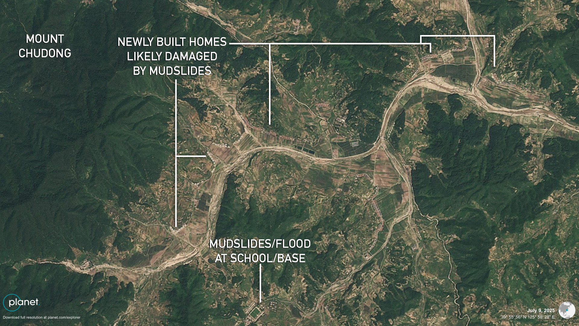
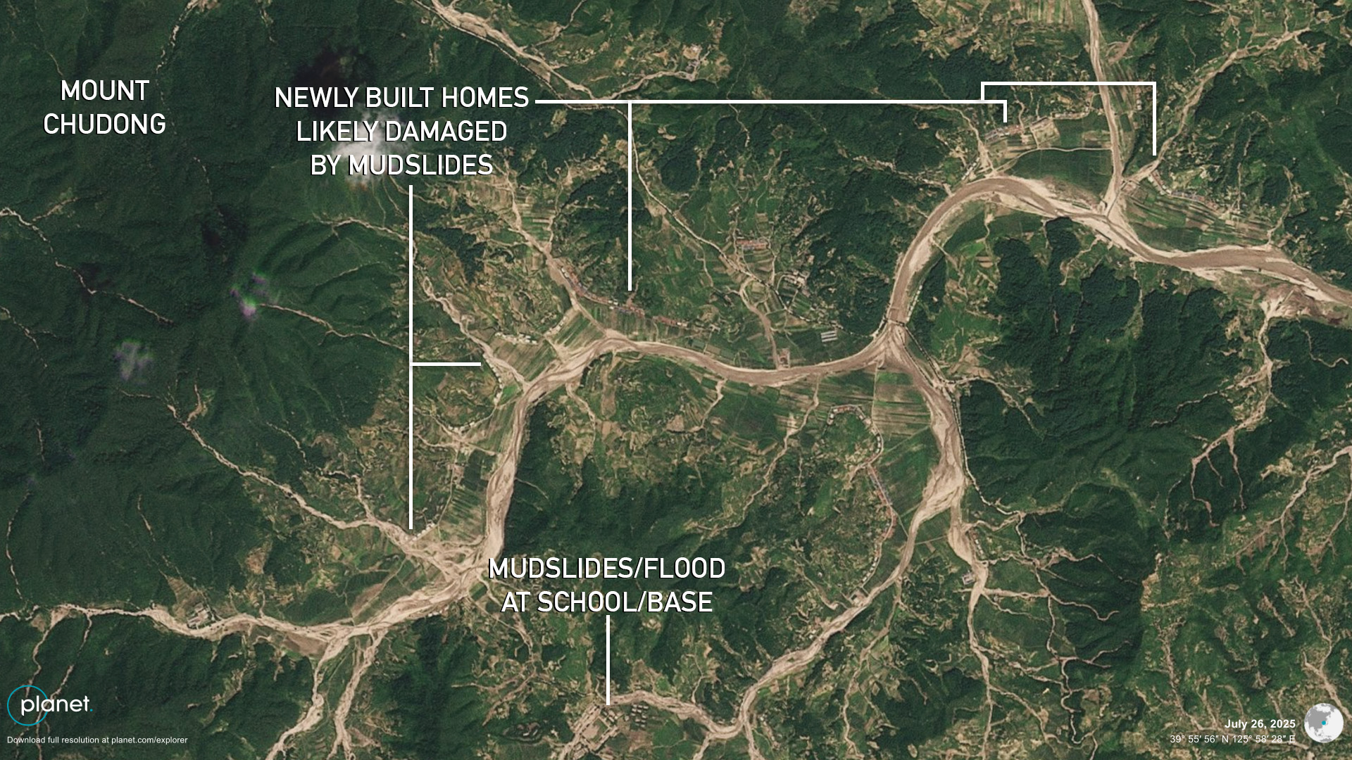
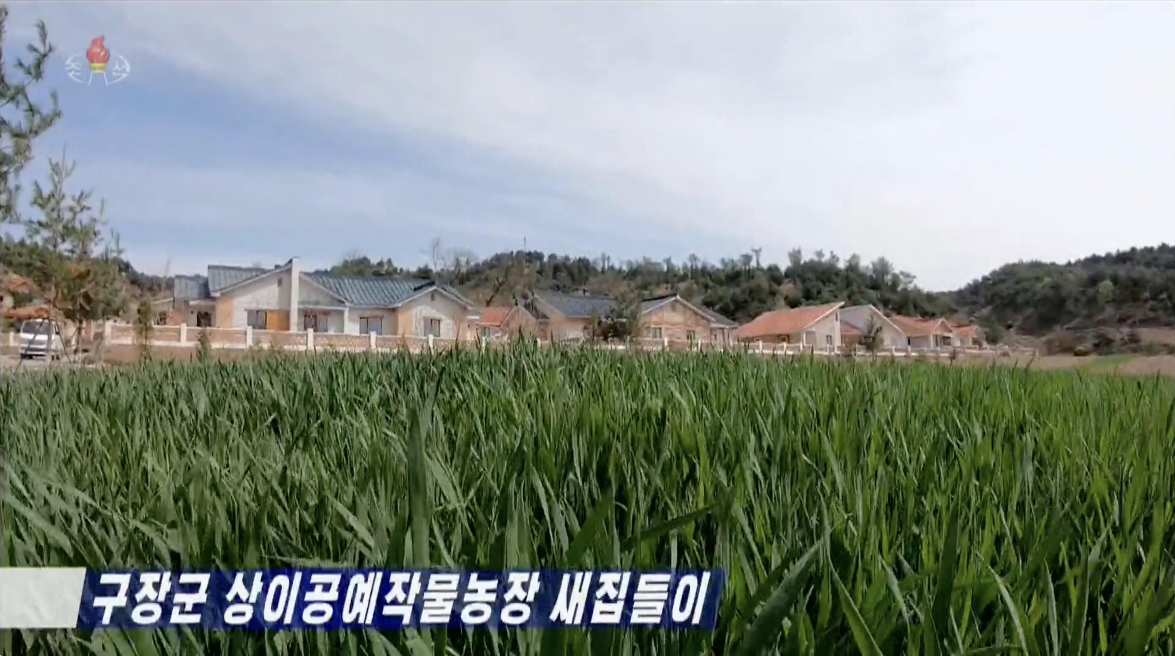
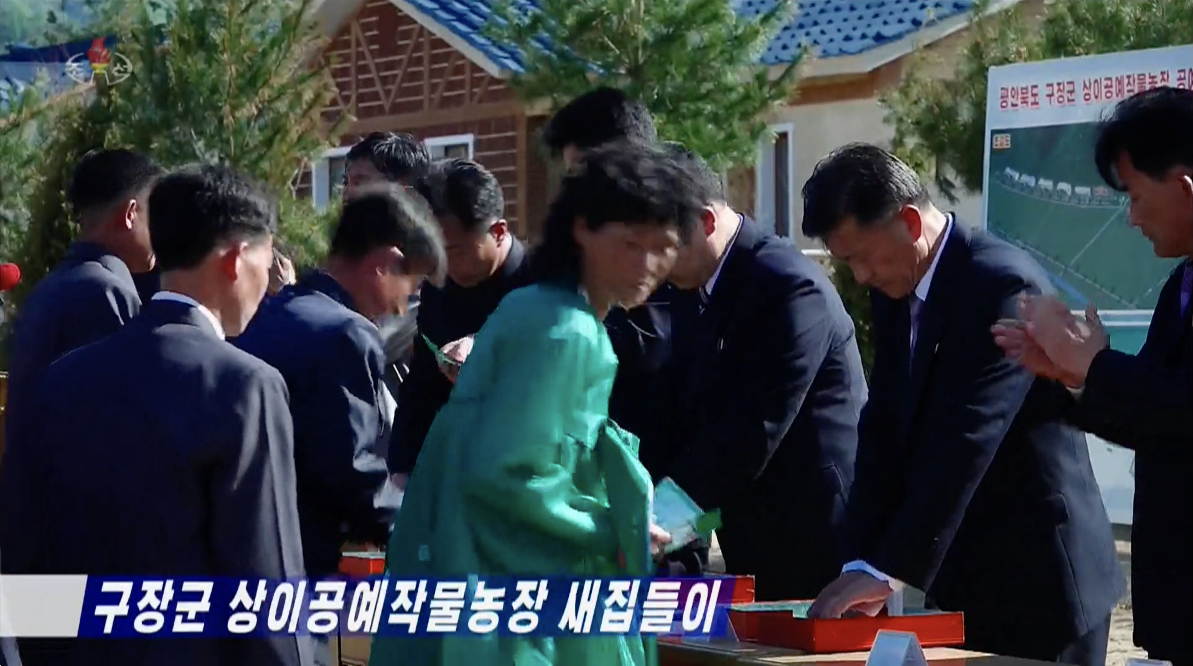
For example, newly built housing in Sangi-ri, Kujang County appeared to be in the path of mudslides or heavy water flows in the latest imagery. The homes were previously featured in April 2024 reports claiming they were gifted by the “motherly” party and Kim Jong Un to locals.
(Before) Comparison of images of Sangi-ri in Kujang County showing dozens of mudslides and overflowing rivers and streams around newly built homes | Image: Planet Labs (July 9, 2025), edited by NK Pro | Coordinates: 39.92584° N, 125.96075° E
(After) Comparison of images of Sangi-ri in Kujang County showing dozens of mudslides and overflowing rivers and streams around newly built homes | Image: Planet Labs (July 26, 2025), edited by NK Pro | Coordinates: 39.92584° N, 125.96075° E
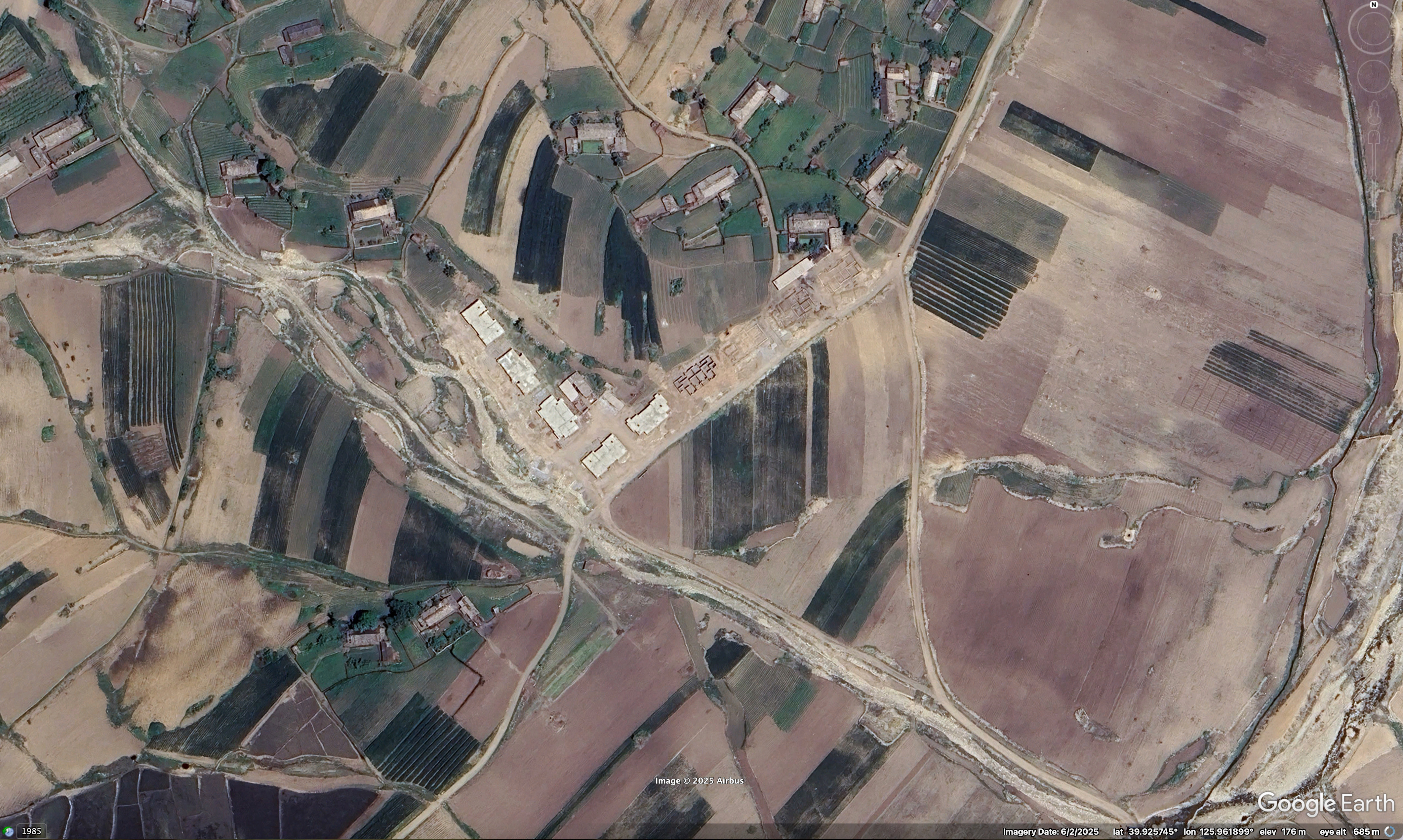
New homes recently under construction in Sangi-ri of Kujang County that appeared to be damaged or destroyed by mudslides from last week’s storms | Image: Google Earth (June 2, 2025), edited by NK Pro | Coordinates: 39.92584° N, 125.96075° E
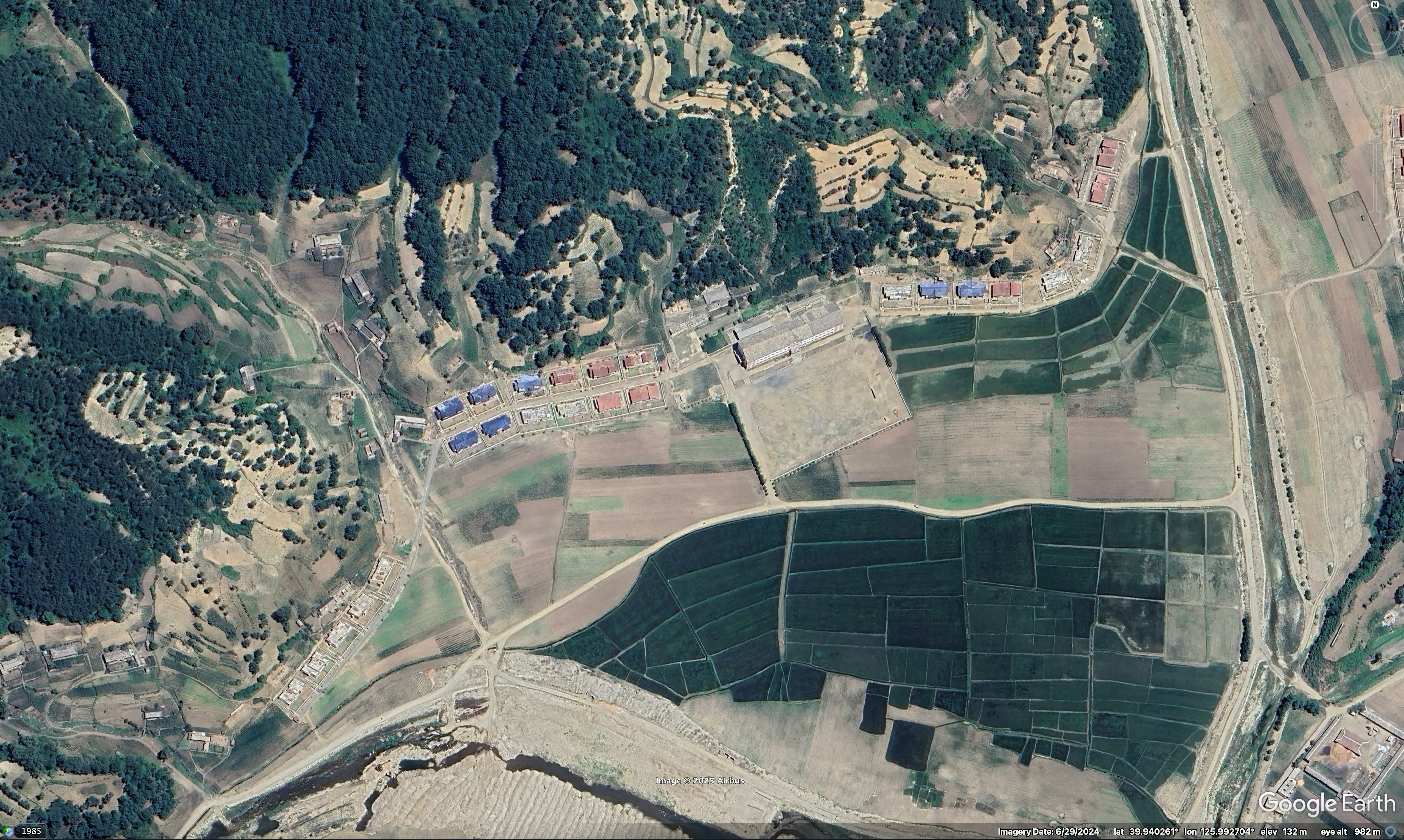
New homes built last year in Sangi-ri of Kujang County that appeared to be in the path of mudslides from last week’s storms | Image: Google Earth (June 2, 2025), edited by NK Pro | Coordinates: 39.94226° N, 125.99169° E
Moving-in ceremonies for new homes in Sangi-ri of Kujang County | Image: KCTV (April 27, 2024)
Moving-in ceremonies for new homes in Sangi-ri of Kujang County | Image: KCTV (April 27, 2024)
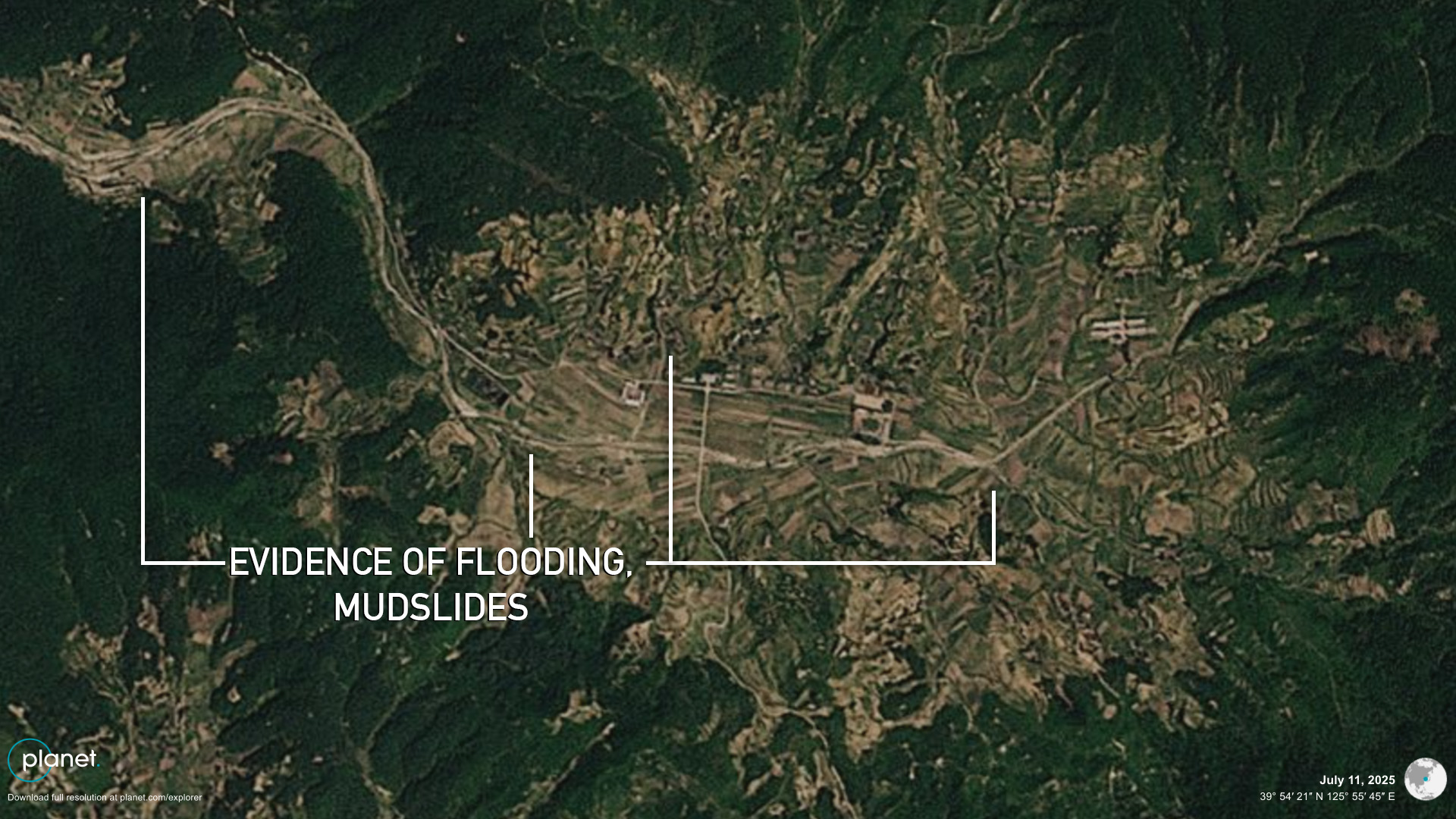
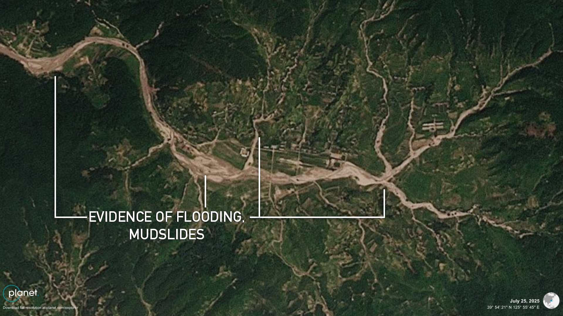
(Before) Comparison showing overflowing rivers and mudslides in Kujang likely damaging old homes and cropland | Image: Planet Labs (July 11, 2025), edited by NK Pro | Coordinates: 39.90644° N, 125.93041° E
(After) Comparison showing overflowing rivers and mudslides in Kujang likely damaging old homes and cropland | Image: Planet Labs (July 25, 2025), edited by NK Pro | Coordinates: 39.90644° N, 125.93041° E
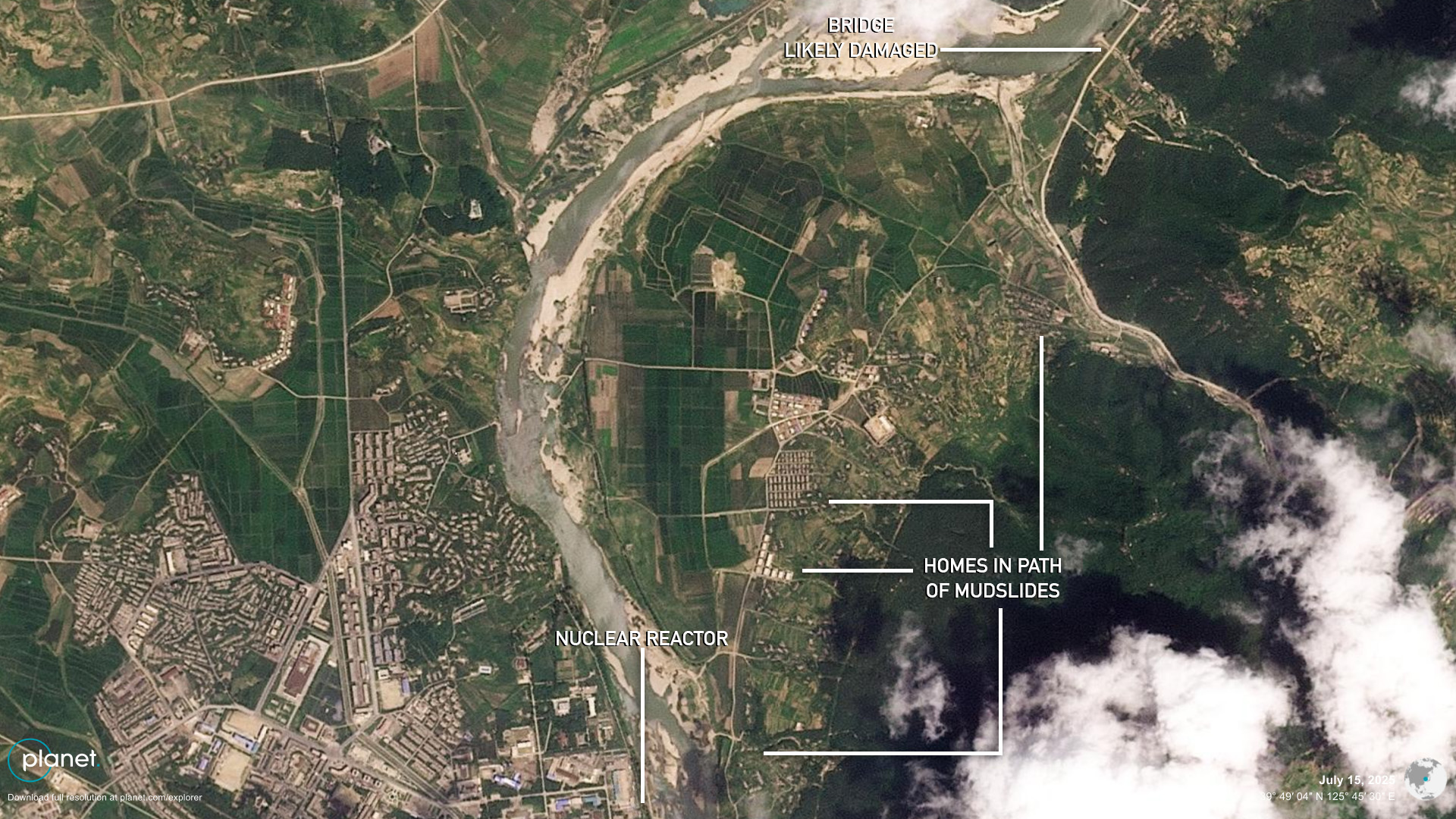
(Before) Comparison showing signs of mudslides at the Yongbyon nuclear complex across the river to the northeast of the main reactor | Image: Planet Labs (July 15, 2025), edited by NK Pro | Coordinates: 39.80958° N, 125.75762° E
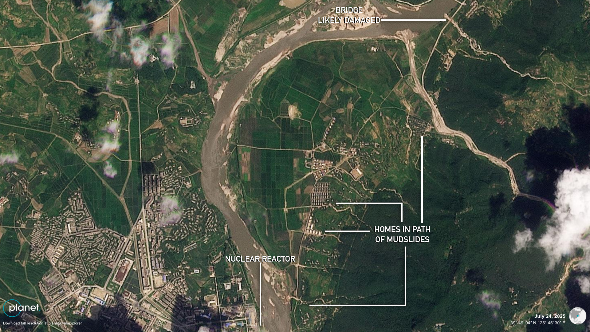
(After) Comparison showing signs of mudslides at the Yongbyon nuclear complex across the river to the northeast of the main reactor | Image: Planet Labs (July 24, 2025), edited by NK Pro | Coordinates: 39.80958° N, 125.75762° E
Small bridges crossing creeks as well as roads and likely some homes were also damaged by water flowing down from mountains right across the river from the main Yongbyon nuclear reactor.
The heavy rains likely created problems for some workers of the nuclear complex, but the reactor site itself appears undamaged.
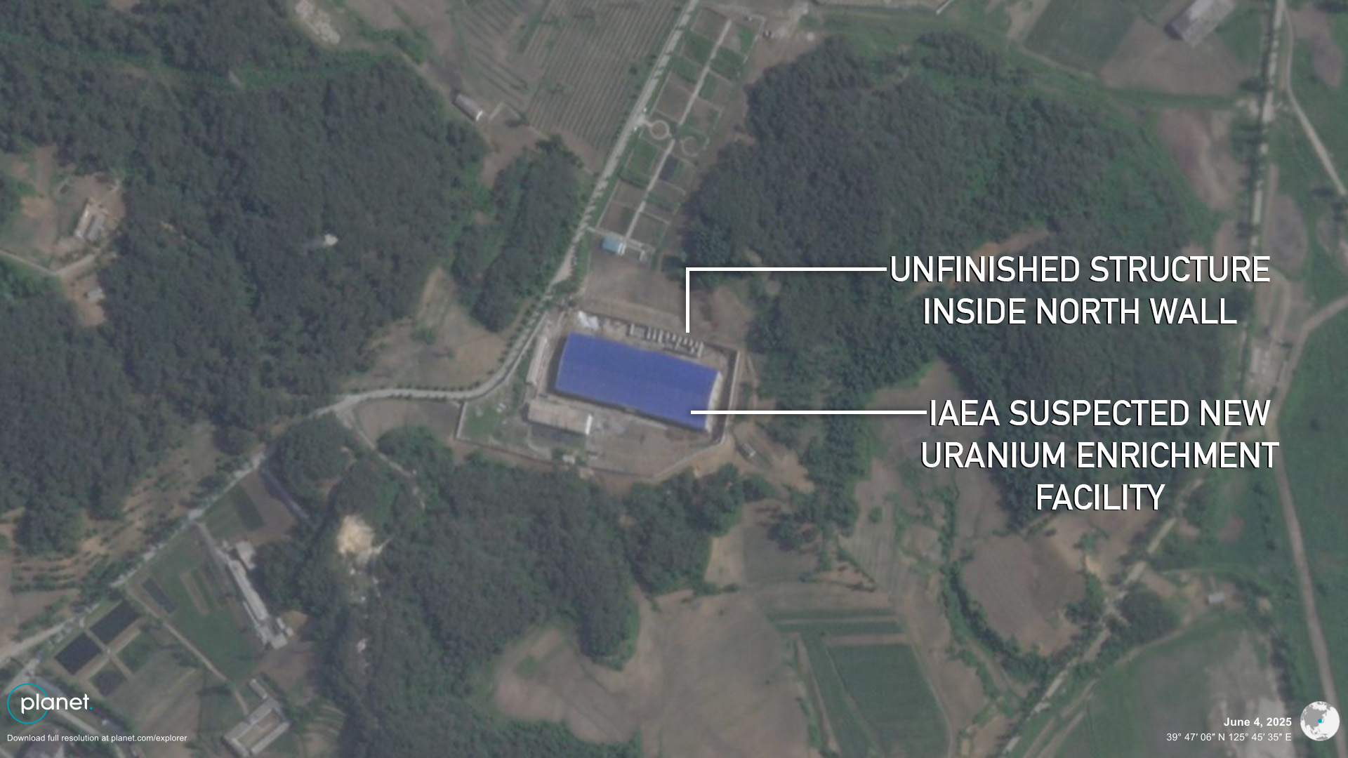
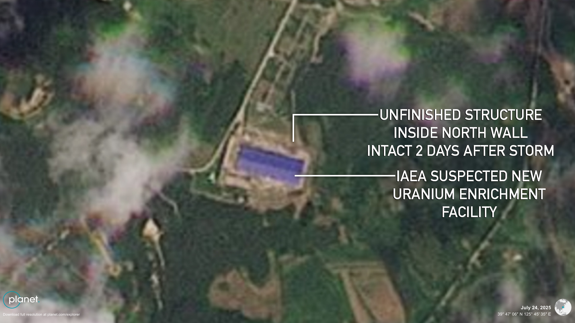
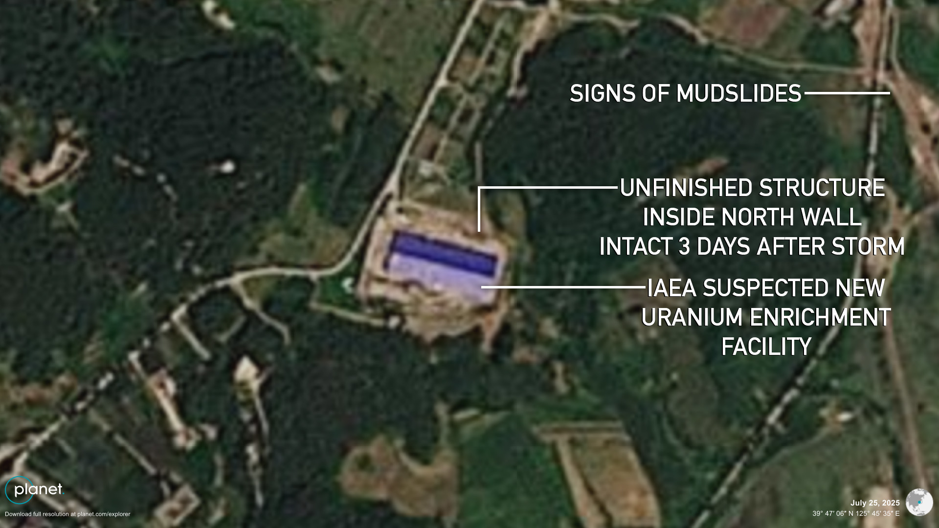
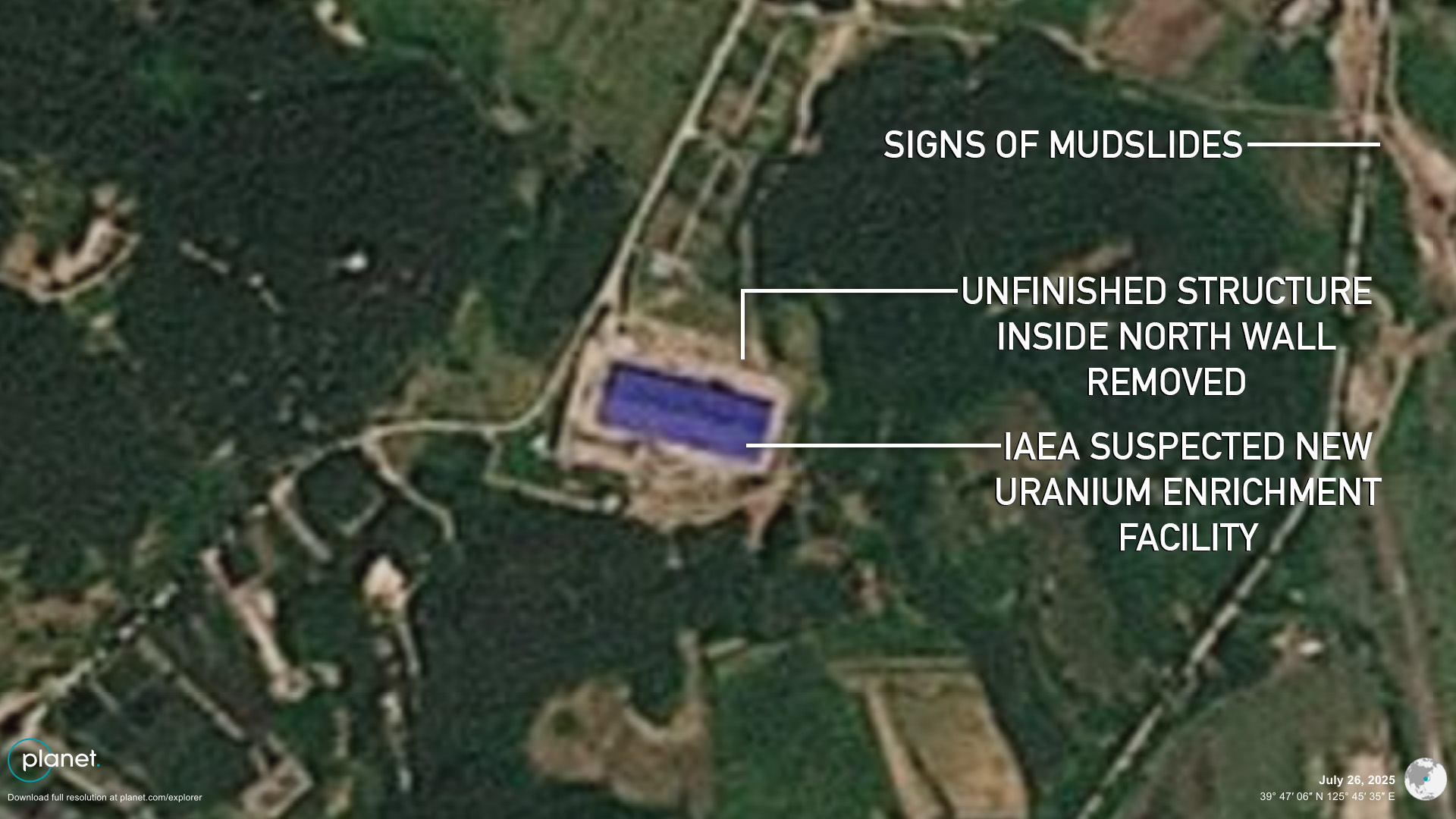
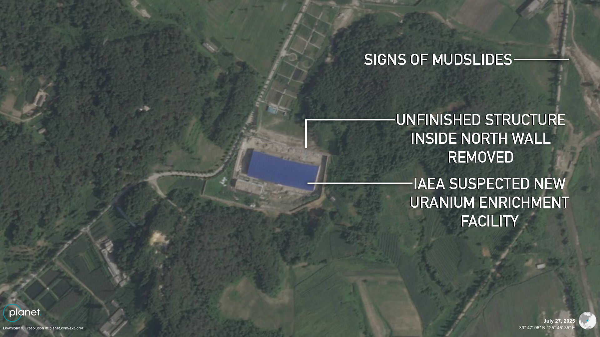
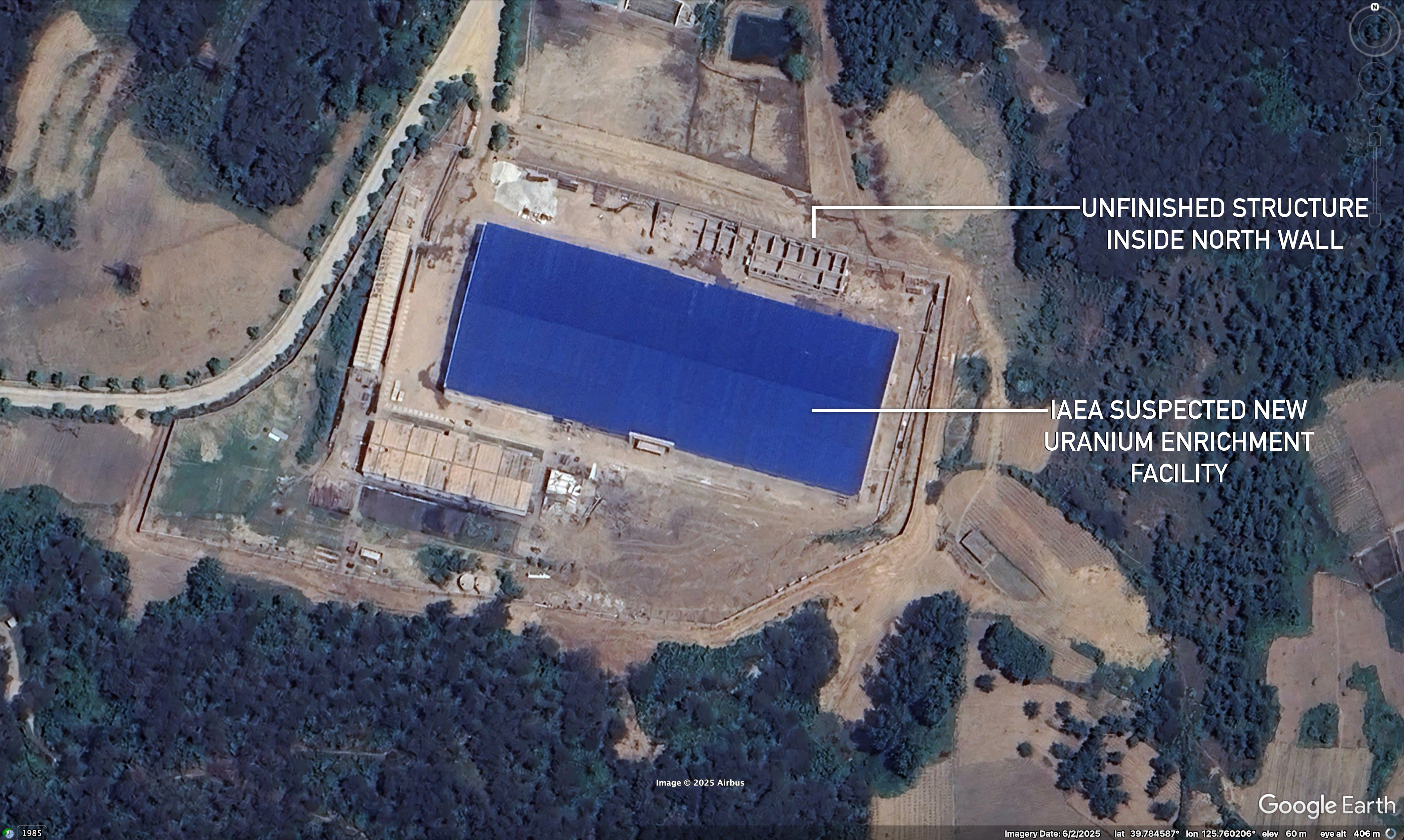
Though inconclusive, imagery also suggests the storm may have been responsible for demolition days later at a new construction site that the International Atomic Energy Agency (IAEA) has identified as a possible uranium enrichment plant.
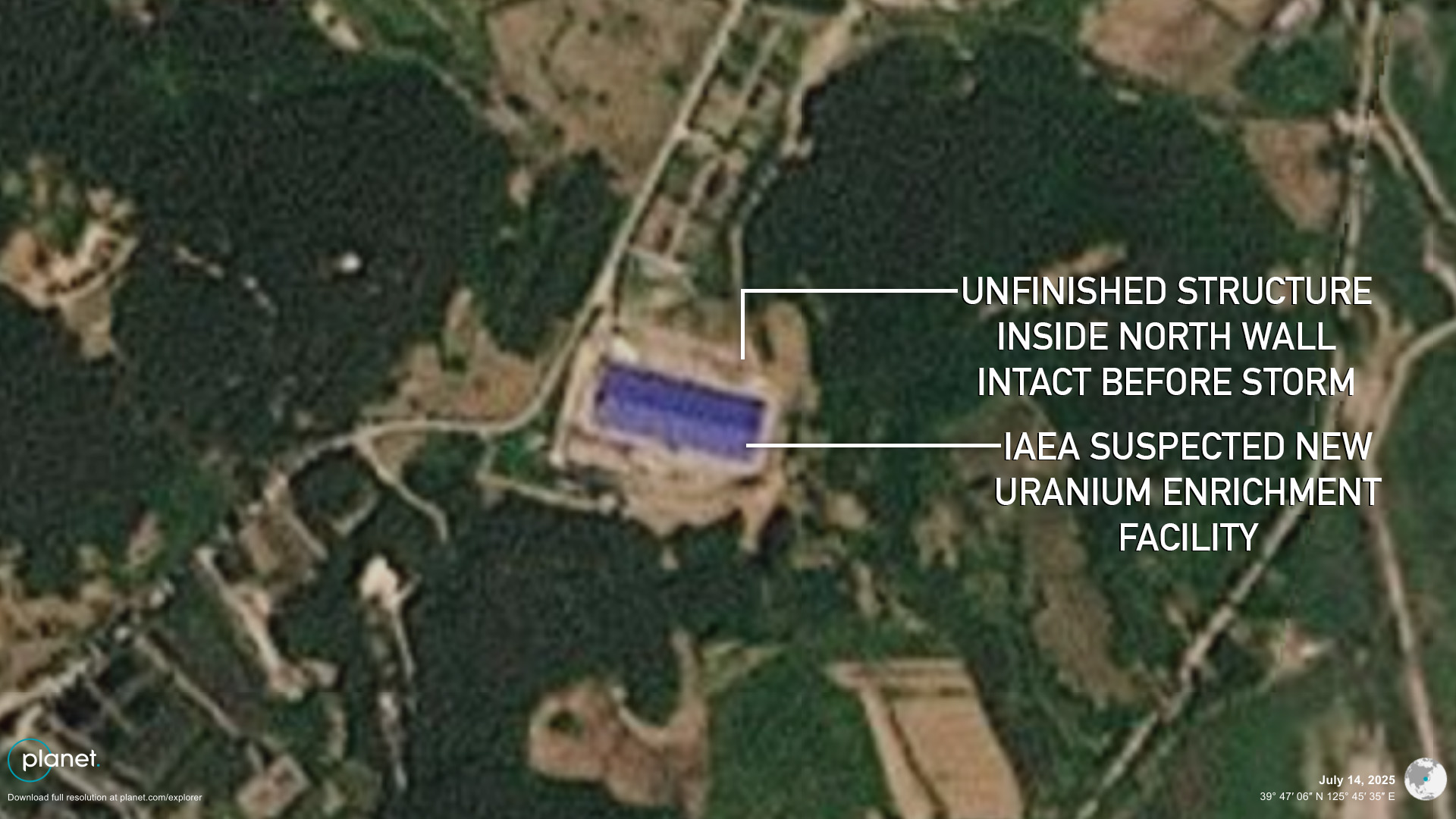
Imagery shows that a partially built structure inside the northern wall of the new compound was taken down between July 25 and 26, potentially due to being damaged beyond repair by the rains. This also raises the possibility that flooding impacted the main building, with evidence of overflowing streams and minor mudslides in the surrounding area as well.
(High-resolution, before storms) These close-up images show the removal of an unfinished structure inside the northern wall of the suspected new uranium enrichment facility around four days after the storms | Image: Planet Labs (June 4, 2025), edited by NK Pro | Coordinates: 39.78501° N, 125.75981° E
(Medium-resolution, before storms) These close-up images show the removal of an unfinished structure inside the northern wall of the suspected new uranium enrichment facility around four days after the storms | Image: Planet Labs (July 14, 2025), edited by NK Pro | Coordinates: 39.78501° N, 125.75981° E
(Medium-resolution, two days after storms) These close-up images show the removal of an unfinished structure inside the northern wall of the suspected new uranium enrichment facility around four days after the storms | Image: Planet Labs (July 24, 2025), edited by NK Pro | Coordinates: 39.78501° N, 125.75981° E
(Medium-resolution, three days after storms) These close-up images show the removal of an unfinished structure inside the northern wall of the suspected new uranium enrichment facility around four days after the storms | Image: Planet Labs (July 25, 2025), edited by NK Pro | Coordinates: 39.78501° N, 125.75981° E
(Medium-resolution, four days after storms) These close-up images show the removal of an unfinished structure inside the northern wall of the suspected new uranium enrichment facility around four days after the storms | Image: Planet Labs (July 26, 2025), edited by NK Pro | Coordinates: 39.78501° N, 125.75981° E
(High-resolution, five days after storms) These close-up images show the removal of an unfinished structure inside the northern wall of the suspected new uranium enrichment facility around four days after the storms | Image: Planet Labs (July 27, 2025), edited by NK Pro | Coordinates: 39.78501° N, 125.75981° E
A high-resolution close-up shot of the new suspected uranium enrichment facility at Yongbyon, showing the unfinished structure in detail inside the northern wall | Image: Google Earth (June 2, 2025), edited by NK Pro | Coordinates: 39.78501° N, 125.75981° E
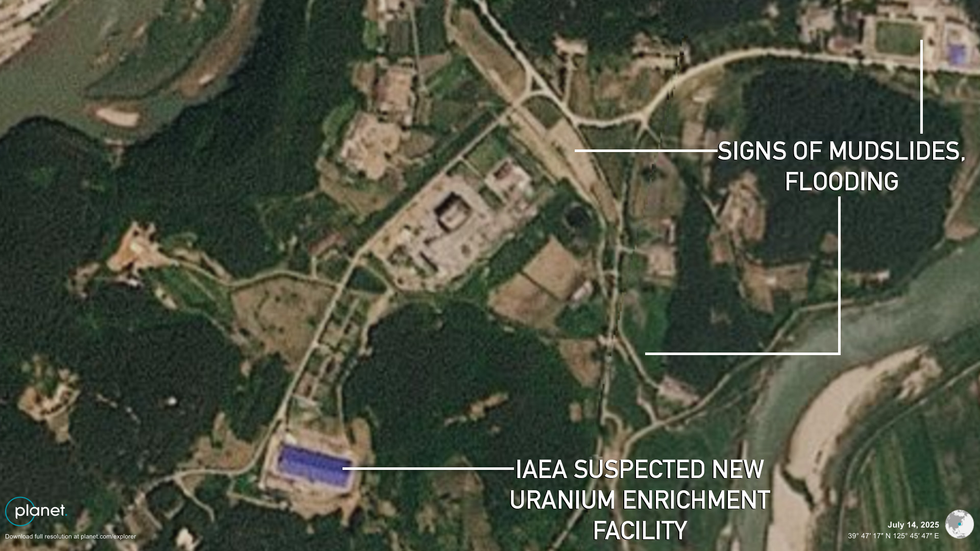
(Medium-resolution, before storms) These wide shots of the suspected uranium enrichment facility area show signs of flooding | Image: Planet Labs (July 14, 2025), edited by NK Pro | Coordinates: 39.78501° N, 125.75981° E
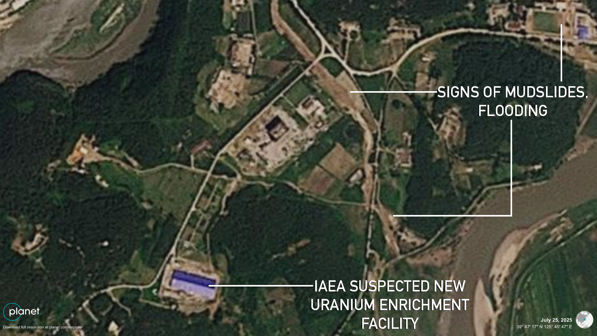
(Medium-resolution, three days after storms) These wide shots of the suspected uranium enrichment facility area show signs of flooding | Image: Planet Labs (July 25, 2025), edited by NK Pro | Coordinates: 39.78501° N, 125.75981° E
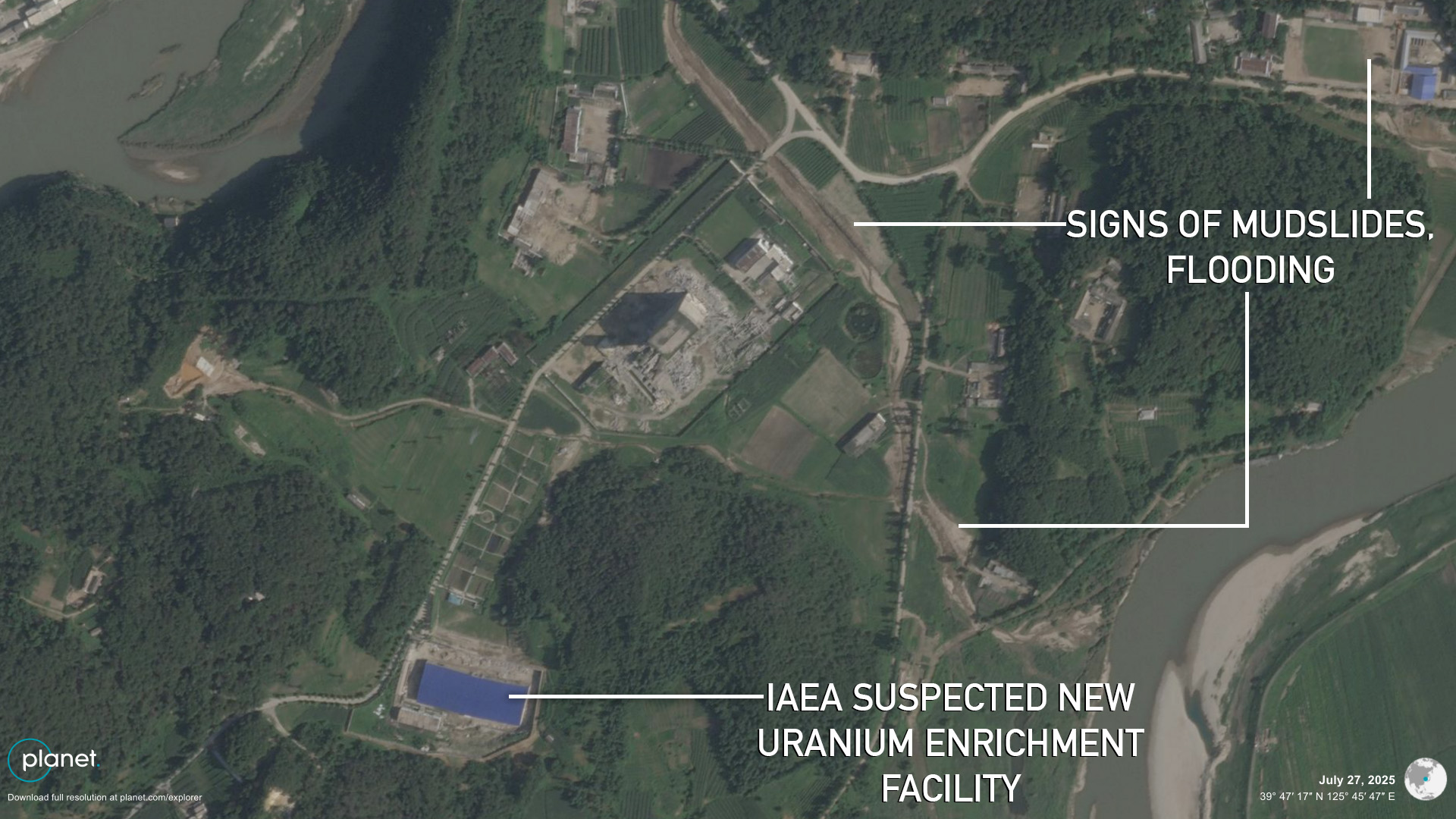
(High-resolution, five days after storms) These wide shots of the suspected uranium enrichment facility area show signs of flooding | Image: Planet Labs (July 27, 2025), edited by NK Pro | Coordinates: 39.78501° N, 125.75981° E
The construction project still appears incomplete, and it remains unconfirmed whether it is a nuclear-related facility.
Imagery shows more isolated patches of mudslides in Unsan County to the north of Kujang, while large volumes of water flowed through a valley to the northeast in Hyangsan County (Myohyangsan) that hosts the Kim family’s prized gifts museum and Workers’ Party plenum retreat facility.
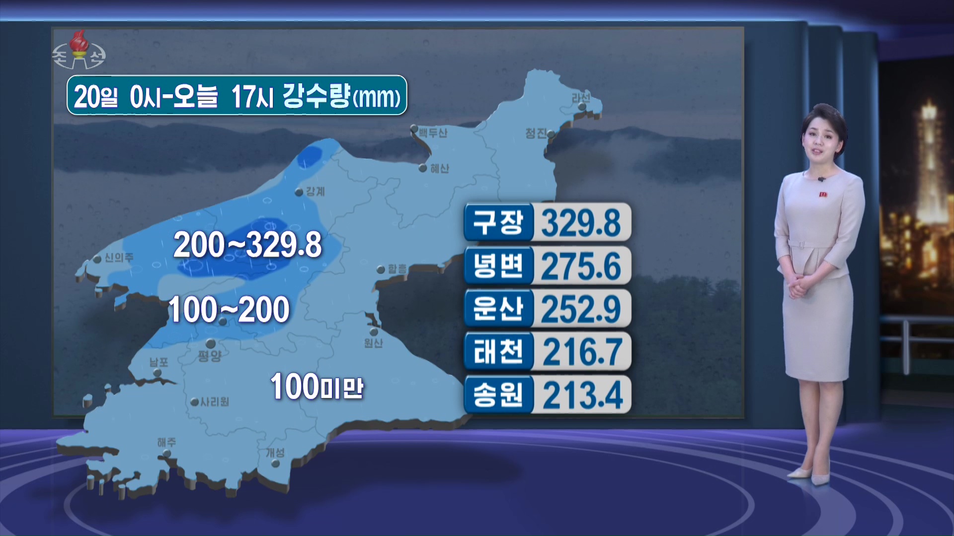
During the 8 p.m. news on July 22, Korean Central Television (KCTV) reported rainfall totals of 329.8 mm (13 in) in Kujang, 275.6 mm (10.9 in) in Nyongbyon (Yongbyon) and 252.9 mm (10 in) in Unsan.
It did not air video footage during the heavy rain of reporters offering situation updates from various locations like it has in the past.
State TV offered rainfall totals for Kujang and Nyongbyon, suggesting they experienced possible damage, but without reporting on actual conditions | Image: KCTV (July 22, 2025)
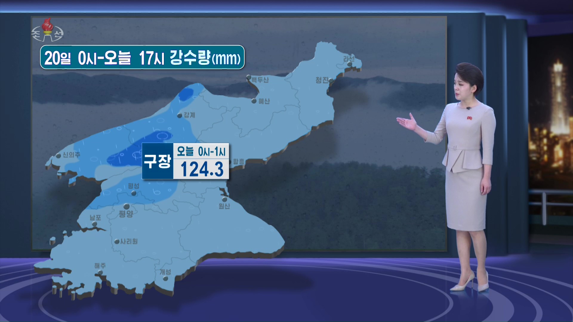
State TV reported that Kujang experienced flash flooding, receiving 124.3 mm of rainfall within one hour from midnight to 1 a.m. on July 22 | Image: KCTV (July 22, 2025)
National state media outlets warned residents of North Phyongan and Jagang Provinces days earlier of severe rain forecasts but without offering more detailed radar animations or specific towns expected to be hardest hit.
It’s possible residents may have had access to more detailed warnings via local radio or weather apps for those with smartphones.
Colin Zwirko is a Senior Analytic Correspondent for NK News based in Seoul. He joined the company in 2018 after receiving a master's degree in international security and foreign policy from South Korea's Yonsei University. Follow him on Bluesky / Twitter.







 SHARE
SHARE COPY LINK
 X
X MASTODON